The Energy Consulting Group
Management consultants for upstream oil and gas producers and service companies
Algerian Oil and Gas, Exploration and Production Industry
The Upstream Oil and Gas Industry In Algeria For Higher Resolution, Click Image |
Web Page Table of Contents (click on the hi-lighted text to go directly to that content) Overview Map of the Algerian Oil and Gas Industry Algerian Oil and Gas Production and Export Volumes/Infrastructure Maps Overview of Algerian Non-Conventional Plays (Shale Gas) Algerian Geology-Detailed (ALNAFT) Legal Framework for Carrying Out Hydrocarbon Research and/or Exploration Activities in Algeria (ALNAFT) 3D Algerian Shaded Relief Map (Rotatable, Zoomable, Roamable) 3D Algerian Shaded Relief Map with Oil and Gas Fields, and Pipelines (Rotatable, Zoomable, Roamable) Go to Energy Consulting Group Home Page |
|
E&P News and Information Scandinavian International and National International Energy
Agency Department of Trade and Norwegian
Petroleum Ministry of Industry
and E&P Project Information |
|---|
|
Algerian Oil Production and Reserves (Note: These are total liquid volumes, so are an amalgam of crude, condensate and NGL production. According to the EIA, Algeria produces about 320 MBLPD of NGL's and about 1200 MBOPD of crude and condensate) 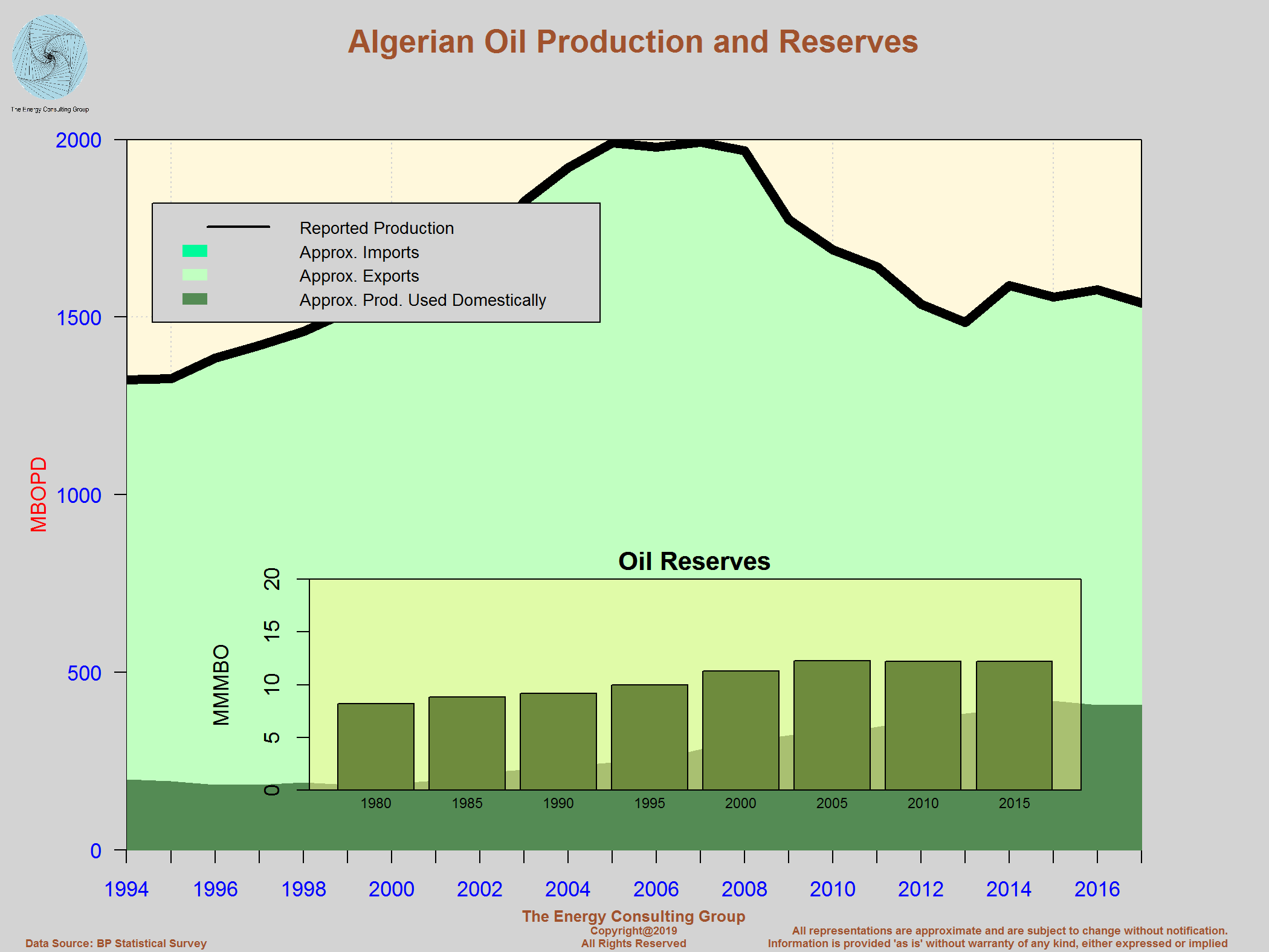 For Larger View, Click Image |
Algerian Gas Production and Reserves  For Larger View, Click Image |
Algerian Oil Production Segmented By Type (Crude, Condensate,
and NGL)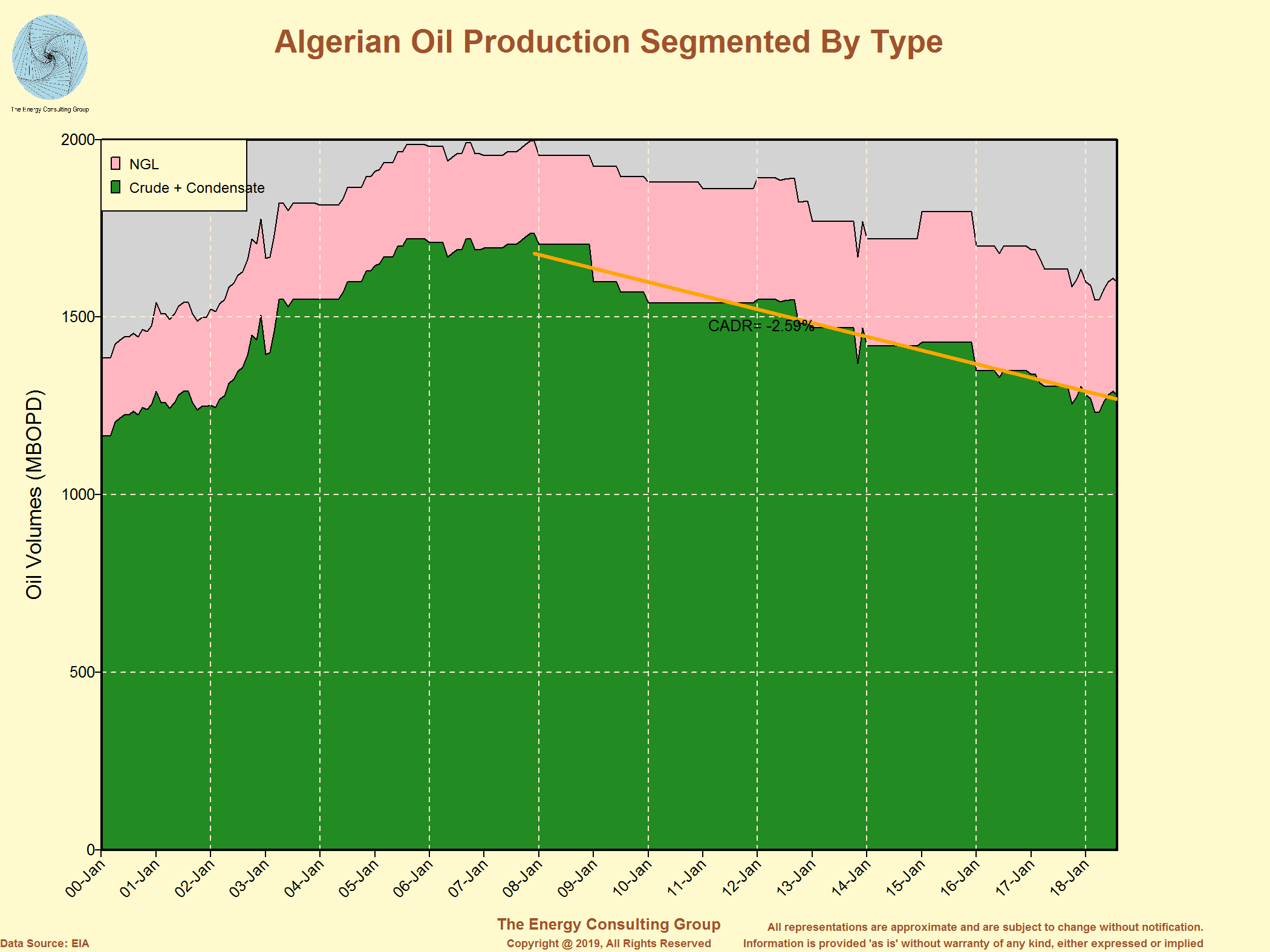 For Larger View, Click Image |
Algerian Oil and Gas Fields on 3D Surface Elev. Map 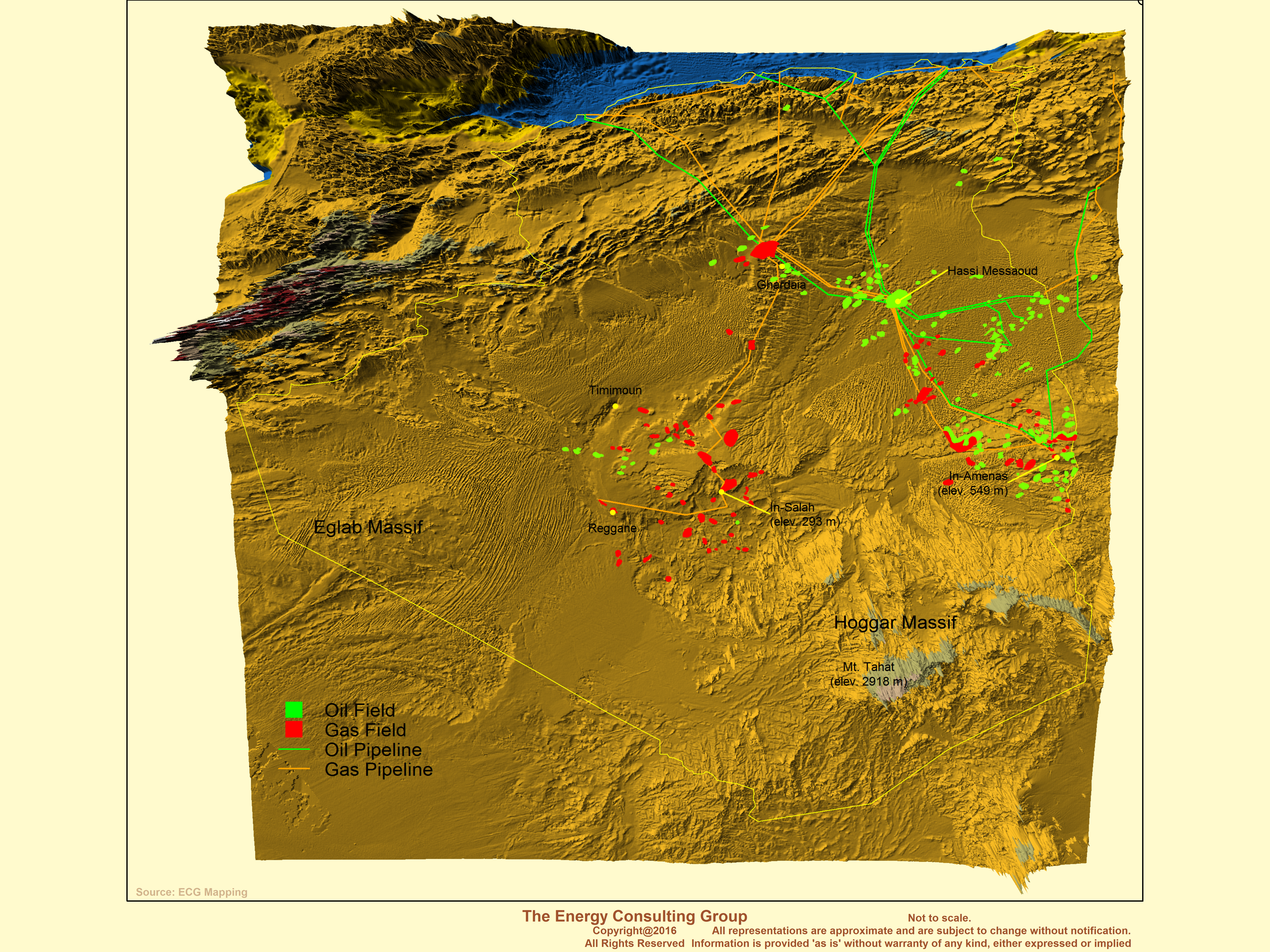 For Higher Resolution, Click Image |
|
Return to Web Page Index |
|
Algerian Hydrocarbon Transport and Export Network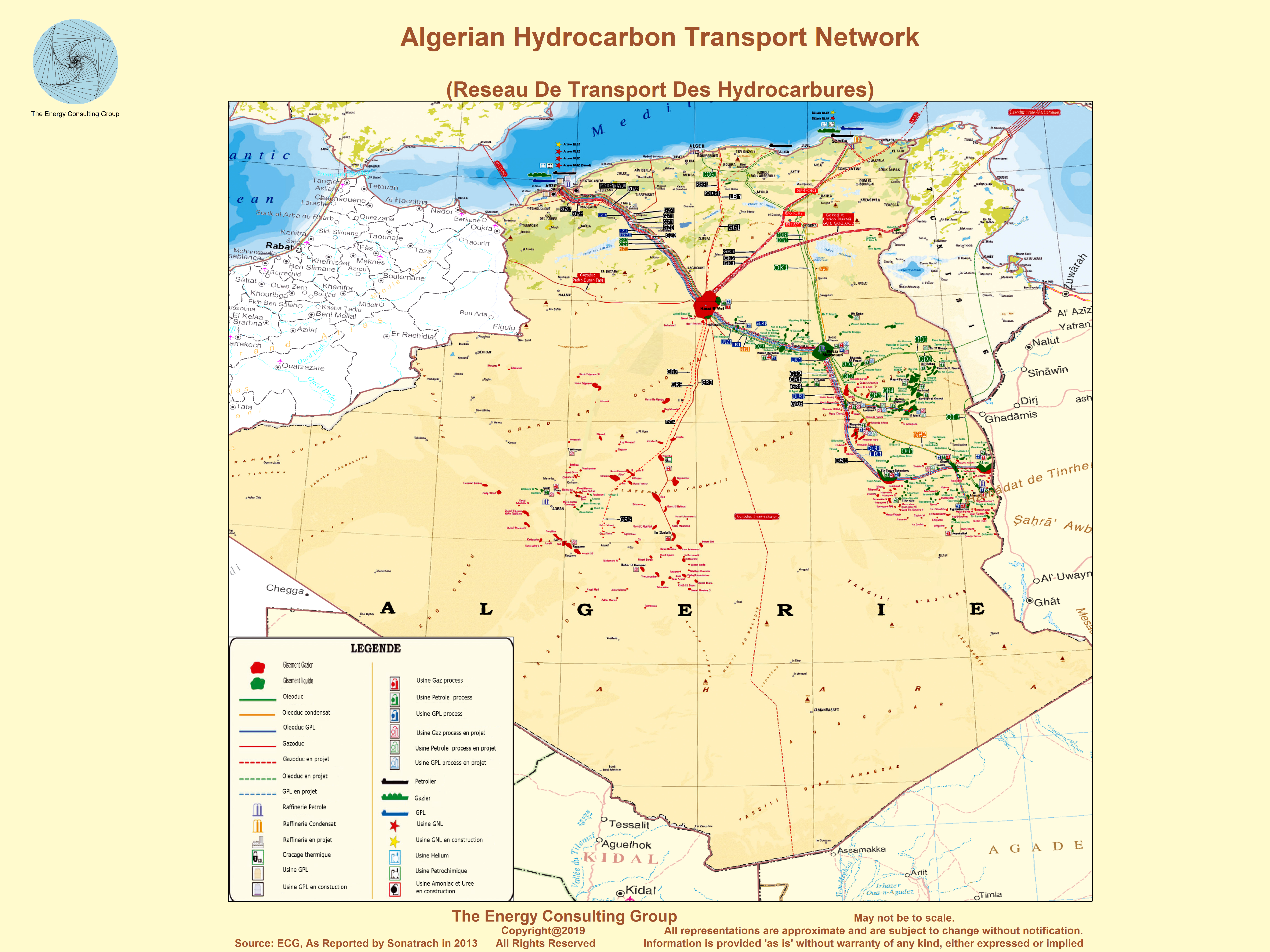 For Larger View, Click Image |
Algerian Natural Gas Export Markets-2013 For Larger View, Click Image |
|
Algerian Oil and Gas Pipelines Relative to Oil and Gas Fields - Circa 2001 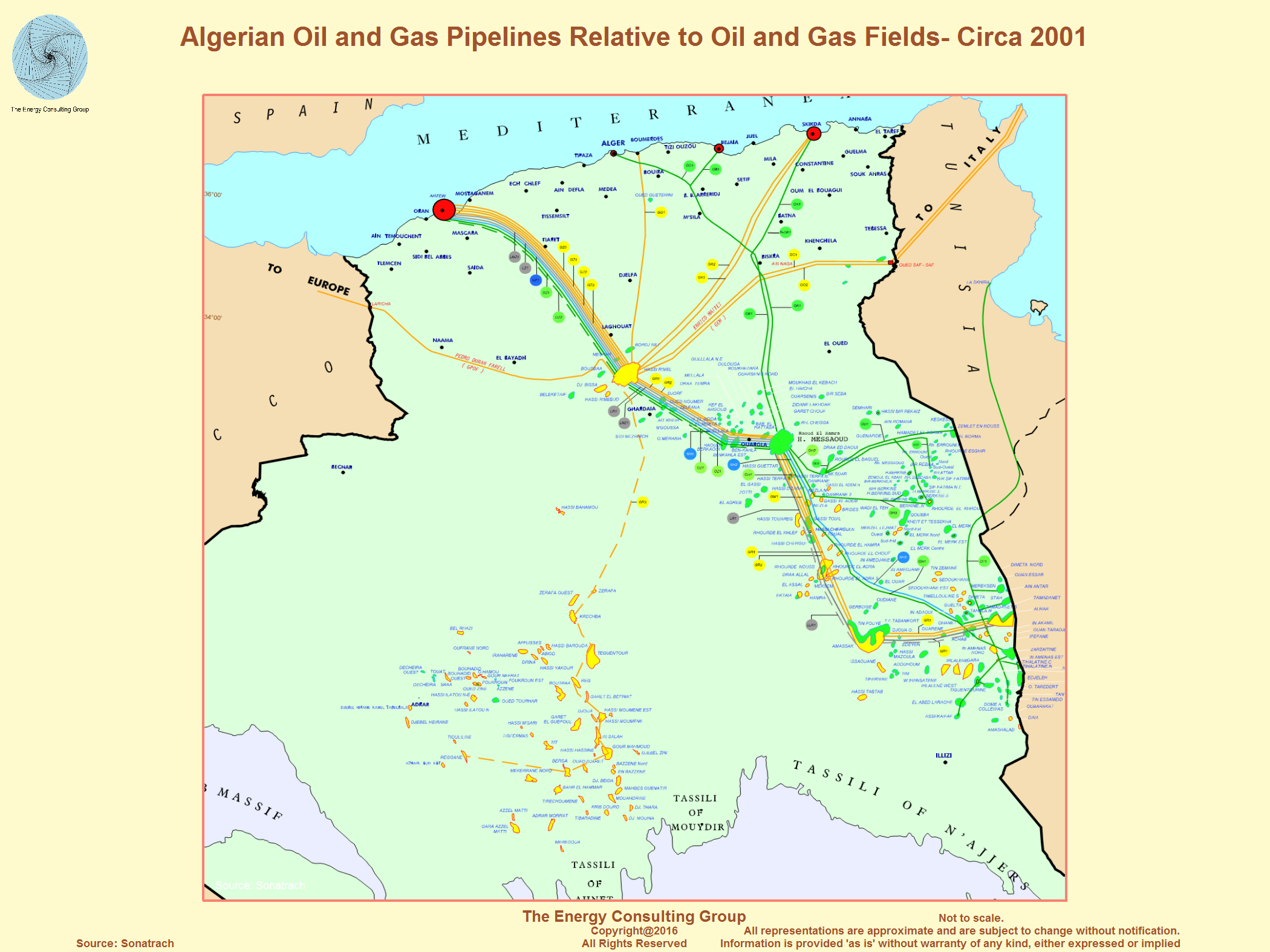 For Larger View, Click Image |
Algeria Pipeline Map (high resolution)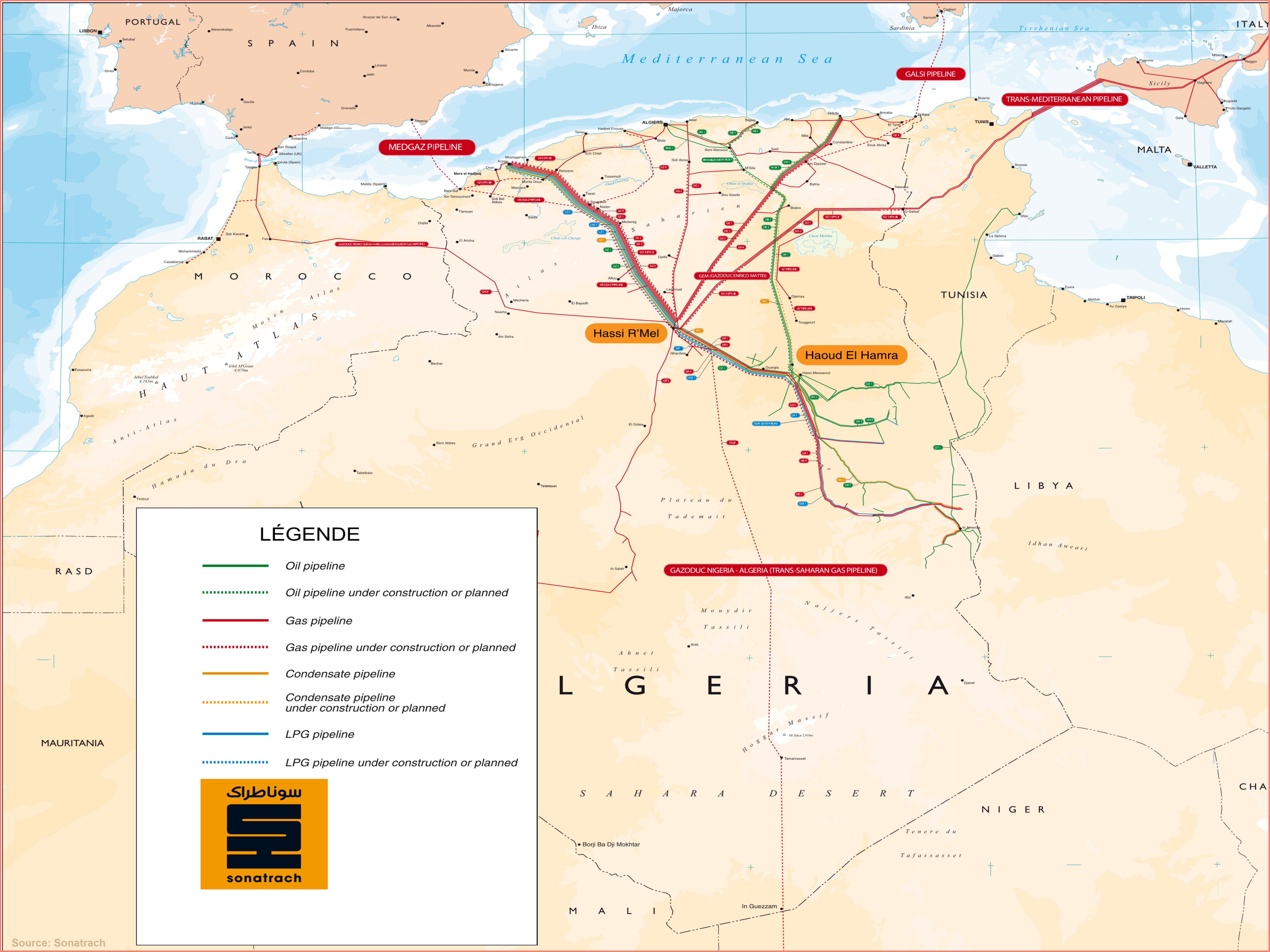 For Larger View, Click Image |
Algerian New Gas-Condensate Field Development: Ain Tsila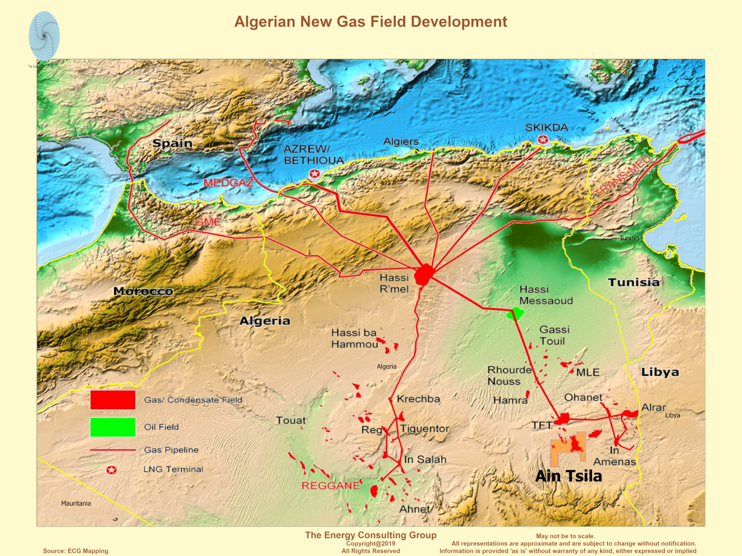 Link to 3D version of the above map. The 3D representations shows how the terrain varies around the new field area, and how the elevation shifts as gas pipelines heads towards the domestic demand and export (LNG and pipelline) centers along the coast. 3D Map Controls: to rotate use the left mouse button, to zoom in/out use the mouse wheel, and to roam use the right mouse button. |
Algiers, March 13, 2019; Ain Tsila Project Approval Announcement
The
Isarene Group (Incorporated by SONATRACH, Petroceltic and Enel)
and PETROFAC International (UAE) LLC today signed an EPC
contract for the development
-
The completion of a CPF for wet gas treatment with a capacity of
12 million m3 Day; |
Algeria: Stratigraphic Column For Larger View, Click Image Stratigraphie de la plate-forme saharienne (A- la province occidentale, B- la province triasique, C- la province orientale) Stratigraphy of the Saharan platform (A-Western Province, B-Triassic province,C-the eastern province ) |
Selected Geologic and Hydrocarbon Basins of Algeria (with some
oil and gas fields)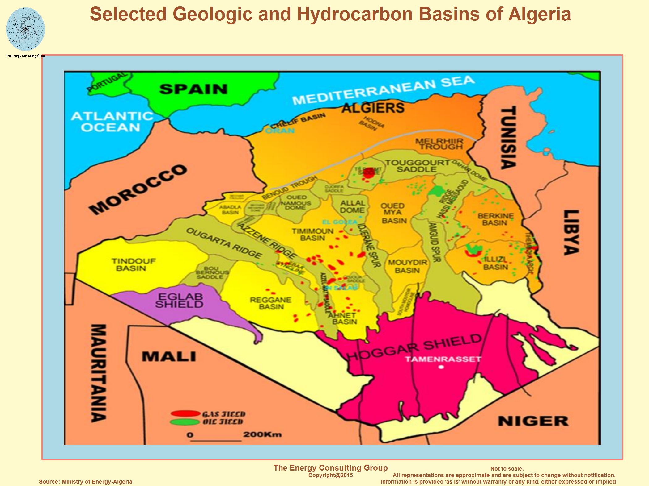 For Larger View, Click Image |
|
To the left is a 3D rendering of the Algerian shaded relief map
shown below. It is rotatable, zoomable, and roamable (per
the directions below).
For a full screen version of the map, go to this link. (Controls for the 3D rendering to the left and online are: to rotate use the left mouse button, to zoom in/out use the mouse wheel, and to roam use the right mouse button.) |
|
The 3D image to the left contains an interactive 3D elevation map of most
of Algeria with an overlay of oil and gas fields and pipelines. It is intended to help
provide geographic context for important oil and gas producing regions
in Algeria. It is rotatable, zoomable, and roamable (per
the directions below).
For a full screen version of the map, go to this link. (Controls for the 3D rendering to the left and online are: to rotate use the left mouse button, to zoom in/out use the mouse wheel, and to roam use the right mouse button.) |
Algerian Non-Conventional Oil and Gas Plays (Shale Gas and Light,Tight Oil)
Algerian Shale Gas:
Ahnet Basin |
It has been reported that ExxonMobil is negotiating an agreement
to develop shale gas fields in the Ahnet Basin, southwestern Algeria
(see exhibit to the left) with
horizontal drilling and fracking technology. The shale gas zones are probably the
Frasnian and Silurian, which Sonatrach tested in 2015, and which
are described in more detail in the following exhibits. Reuters is reporting that ExxonMobil has temporarily suspended the above referenced negotiations due to the nascent anti-government protest movement that emerged in March 2019. |
Algerian Shale Gas
Overview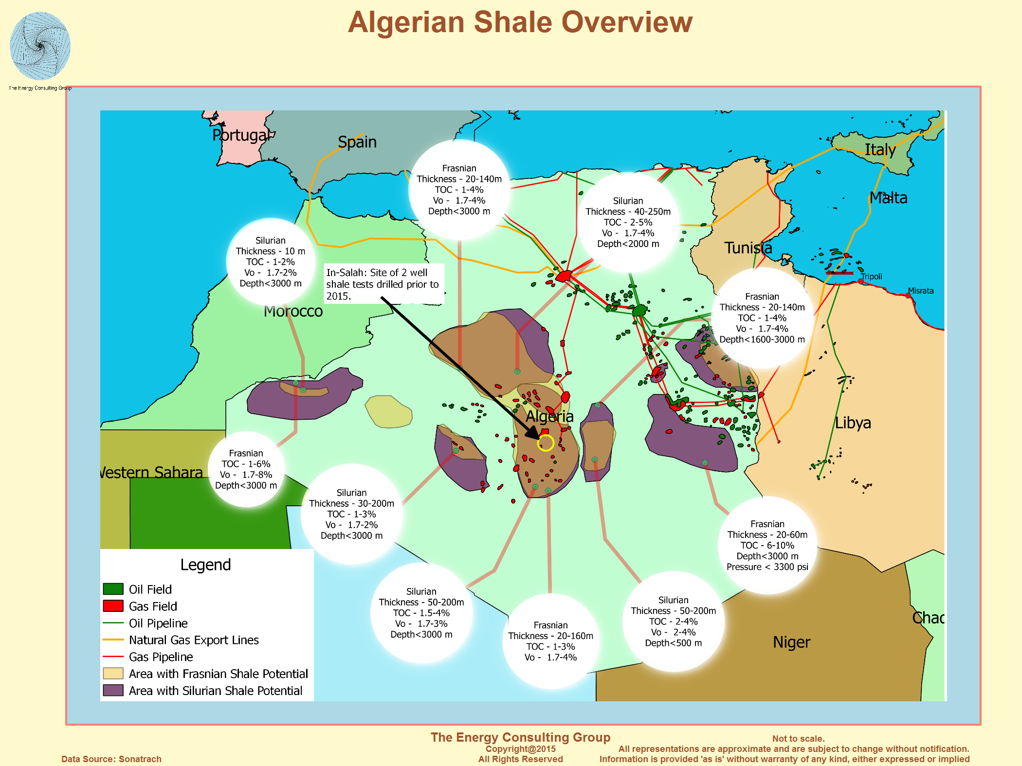 |
Play Characteristic Comparison Between Frasnian Shale and Well
Known US Shales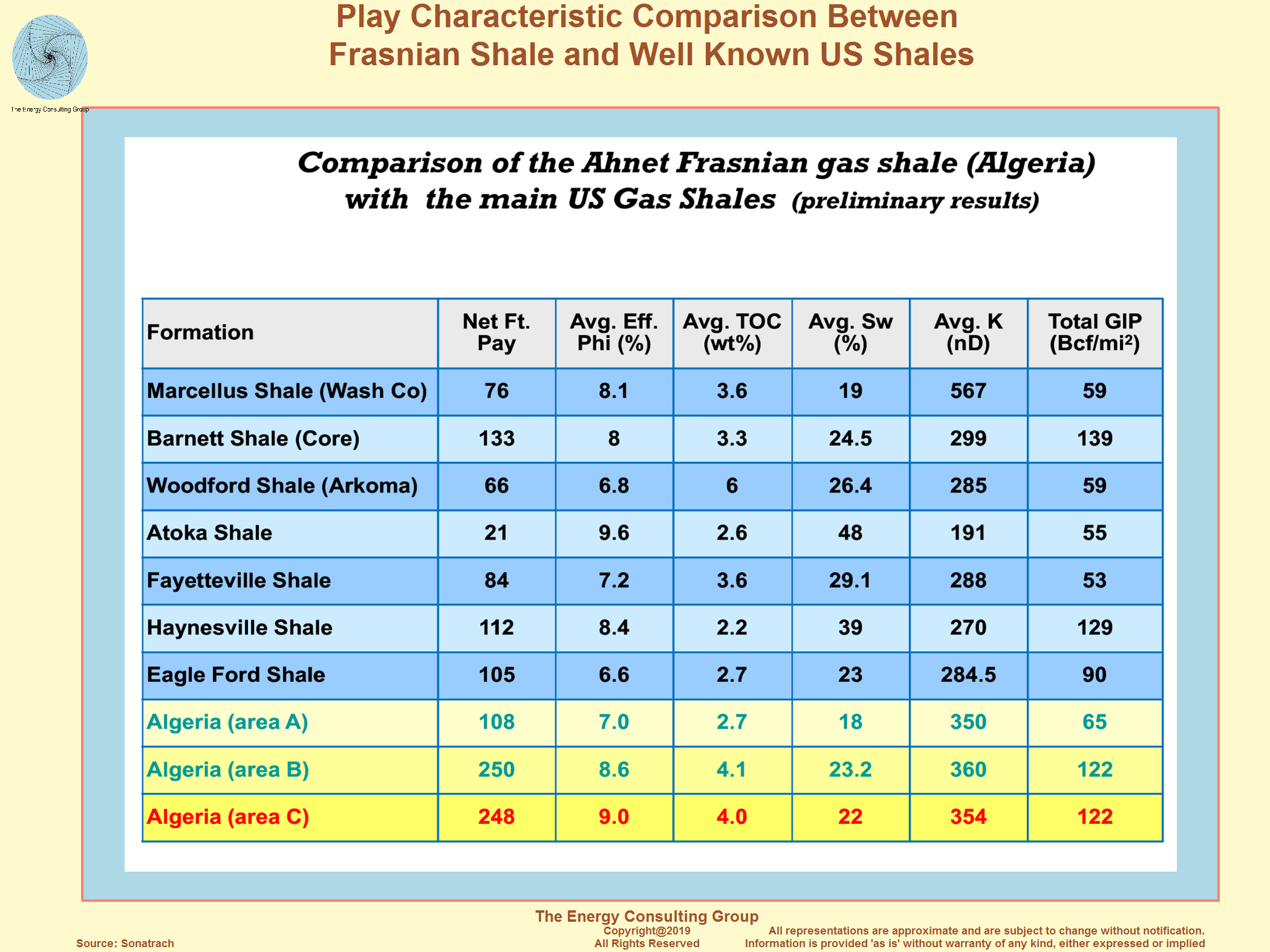 |
Algerian Shale Gas
Potential: Frasnian Formation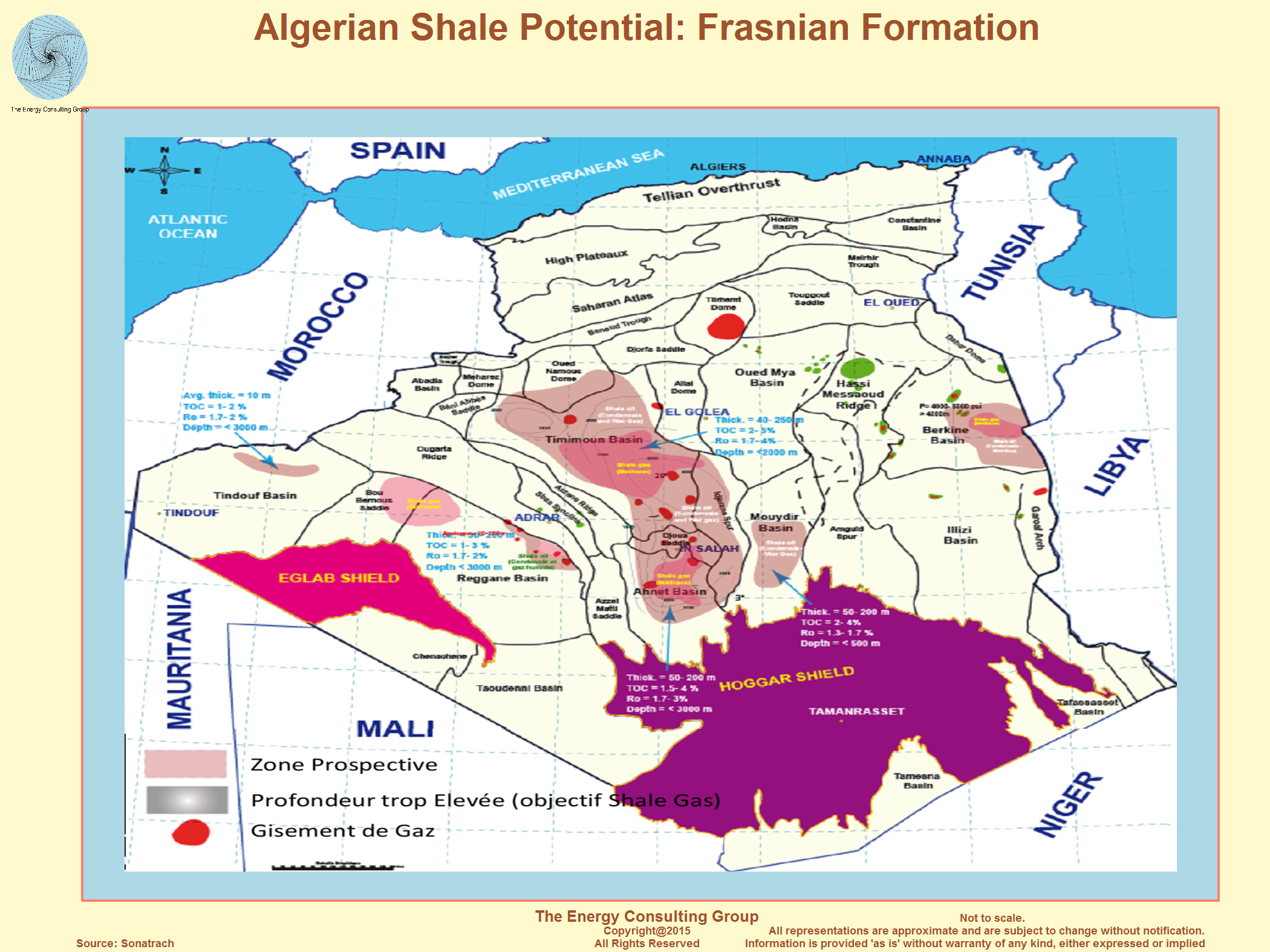 |
Algerian Shale Gas Potential: Silurian Formation |
1.INTRODUCTION:
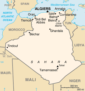
The boundaries of Algeria are the Mediterranean Sea to the north (1200 km of
coast), Morocco to the west, Tunisia and Libya to the east, Mauritania and
Western Sahara to the south-west and finally Mali and Niger to the south (Fig.
1).

Fig.1: Geographical map of Algeria
2. GEOLOGICAL FRAMEWORK
The geological history of Algerian sedimentary basins (Fig. 2) is part of the
global geodynamic process of plate tectonics that has structured Algeria in two
domains:
·
in the north, alpine Algeria;
·
to the south, the Saharan Platform.
Fig. 2: Structural Map of Algeria
2.1 ALGERIA ALGERIA:
The northern domain consists of young reliefs, modeled during the Tertiary by
the Alpine movements.
Alpine Algeria is composed of the following structural-sedimentary ensembles,
from north to south:
• the reduced Algerian continental shelf, with tertiary and quaternary deposits
(1000 to 3500 m), is based on a metamorphic base.
The main oil objective is the Mio-Pliocene;
• The Tell Atlas is the domain of aquifers, with basins of intramontane type (eg
Chélif basin), whose sedimentary series extends from Jurassic to
Miocene. Several deposits of variable interest are known there: Ain Zeft,
Tliouanet, Oued Guettirini. The main oil objectives are middle Cretaceous,
Miocene and allochthonous Eocene;
• The Hodna is a pre-pit basin whose filling sequence begins with continental
deposits of Eocene and Oligocene age and continues with a marine Miocene.
The main oil target is the Eocene;
• the highlands, alpine foreland, with reduced sedimentary cover, where local
processes of distension have allowed the formation of intramontane basins such
as those of Telagh and Tiaret. The main oil goal is the Lias;
• The Saharan Atlas was born from a long subsident furrow pinched between the
highlands and the Saharan Platform. In the Mesozoic, this furrow was filled by a
powerful sedimentary series (7000 to 9000 m). During the Tertiary, a compressive
tectonics reactivates the previous extensive structures in faults and inverse
structures resulting in the formation of this mountain range. The main oil
objective is Jurassic.
• the Chott Melrhir basins in the Constantine SE, structured in the Cretaceous
Tertiary Tertiary (5000 m), generated and accumulated hydrocarbons mainly in the
Cretaceous (Djebel Onk, Rass Toumb, Guerguet North El Kihal).
2.2 THE SAHARIAN PLATFORM:
It is located in the south of alpine Algeria and belongs to the North African
craton. It includes a Precambrian basement on which rests a powerful sedimentary
cover, structured in the Paleozoic in several basins separated by high zones. We
distinguish from west to east:
• the Tindouf and Reggane basins located on the northern and northeastern
borders of the Reguibat Shield. The sedimentary cover would reach 8000m in the
Tindouf basin and 6500m in the Reggane basin. In this little explored zone,
Paleozoic formations could be found in liquid and gaseous hydrocarbons;
• the Béchar basin bounded on the north by the High Atlas, to the south and west
by the Ougarta range. Its sedimentary cover would reach 8000m. The reservoirs
are found in lower Paleozoic detritic and Carboniferous reefs;
• the Ahnet-Timimoun basin bounded on the north by the Oued Namous highland, on
the west by the Ougarta range, on the south by the Touareg shield and on the
east by the Idjerane-Mzab ridge . Coverage would average 4000 m. In the south,
the lower Ordovician and Devonian reservoirs are gasiferous. To the north, in
the Sbaa basin, oil has been found throughout the Paleozoic;
• the Mouydir and Aguemour-Oued Mya basins are bounded on the west by the
Idjerane-Mzab Ridge and on the east by the Amguid-El Biod Ridge. In the south,
Paleozoic sediments are exposed in Mouydir. To the north, in the Aguemour-Oued
Mya depression, filled by a powerful Paleozoic and Meso-Cenozoic series (5000m
at Oued Mya), significant deposits have been found in the Cambrian (Hassi
Messaoud) and Triassic ( Hassi Rmel);
• The Illizi-Berkine syncline is bounded on the west by the Amguid-El Biod ridge
and on the east by the Tihemboka mole and the Tunisian-Libyan borders. In the
Ghadames basin, the sedimentary cover (greater than 6000 m) contains hydrocarbon
deposits in the Paleozoic and Triassic.
3. GEODYNAMIC EVOLUTION
The formation of the Mediterranean alpine chains including the Algerian section
of this chain is linked to the rotation of Africa in relation to Eurasia. This
rotation is a slow drift of the two continents towards each other. The initial
stages of this convergence, detected as early as the Early Jurassic, did not
manifest themselves until after the Upper Jurassic (150 Ma).
The tectonics is that of the Africa-Europe collision. The Algerian alpine chain,
which leans against the northern fringe of the southern block, was born of this
collision.
Although the beginning of Africa's drifting movements from Europe is only clear
from the Malm, the initialization of the phenomena dates from the Lias (180
Ma). They are associated with the opening of the North Atlantic.
Schematically, this opening takes place from south to north and generates a
number of phenomena whose effects on Algeria can be summarized as follows:
During the Jurassic period (180-140 Ma), south of the current Azores-Gibraltar
fracture zone, Africa and the continental blocks attached to it separate from
the North America-Europe block (Fig. 5a). The general direction of the Atlantic
is NS while the future Mediterranean alpine zone takes an EO direction. This
direction is determined by the relative movement of Africa relative to
Europe. This movement, of sliding component sinister, persists until the
superior Cretaceous.
In the lower Cretaceous, Spain, acting as a corner opposite the slide, separates
from the America-Europe bloc. The drift of Spain is responsible for the finite
Jurassic-Eocretacea compression phase, as shown by the folds encountered in the
Middle Atlas. During the Cretaceous, as a result of the opening of the North
Atlantic basin (Fig. 5b), there is a decrease in the sinister slide.
The opening would have caused the cancellation of the sinister component of the
movement and even its "inversion". The convergence component of the two
continents, which remained in the background during the Cretaceous period,
became dominant during the cancellation of late Cretaceous slides.
During the Tertiary, a number of remissions and convergences are recorded,
alternating with more or less distensive phases.
From the Eocene, most of Western Europe is stabilized in a form close to the
current one. There is no active subduction zone in the western Mediterranean,
and the collision front extends from the west from the Pyrenees all the way to
the east. It is the zones of lithospheric weakness, mainly areas of Cretaceous
deformations, which absorb the effects of the collision. This generalized
compression provokes deformations on the European bloc and on North-Continental
Africa.
In the Oligocene, as a consequence of the conjugation of the north Atlantic
opening, in the west, and the East-Africa collision, in the east, the western
Mediterranean regions are subjected to a general tectonic regime of
distension. It is responsible for the large intracontinental grabens systems
affecting all of Europe from Spain to the North Sea.
The Mio-Pliocene sees the resumption of Africa-Europe convergence, implying the
resumption of tectonic deformations in the western Mediterranean.
At the level of the Azores-Gibraltar line, the convergence has a sinister
component which manifests on the one hand by activating local points of
subduction and on the other hand, by generating an intracontinental tectonics at
the level of the Pyrenees, the Iberian Chain and of the High Atlas. At the end
of the cycle, the crushing constraints generate the large sheets like the south
vergence of the Atlas Tellien especially developed between El Asnam and Annaba.
4. THE PETROLEUM PROVINCES
From the oil point of view, we distinguish, across the entire mining sector of
Algeria, four more or less mature provinces:
·
The Eastern Sahara, with known deposits of oil and gas, still has good potential
for discoveries;
·
The Central Sahara, considered as gas (deposits of varying importance) but where
recent discoveries of oil can hope for further developments;
·
Western Sahara is mainly considered globally gas with the exception of the oil
discoveries highlighted in the reservoir of Tournaisien basin Sbaa, its
resources remain virtually unknown;
·
In northern Algeria, integrating offshore basins, which despite small oil and
gas discoveries, the oil potential has not yet been revealed due to a complex
geology.
5.STRATIGRAPHIE
It is organized into two distinct areas as those already mentioned.
On the one hand, the Saharan Platform is a very large and stable region that has
been modeled since the Paleozoic and subdivided into three oil provinces.
On the other hand, the north of Algeria, modeled during the Tertiary by the
Alpine movements, has several different sets of stratigraphic characters.
5.1 THE SAHARIAN PLATFORM
The thicknesses of the series (1000 to 8000 m), their nature, the tectonic
deformations and the subsidence, shaped the Saharan Platform in a number of
basins distributed in the western province, the eastern province and the triasic
province.
Fig. 3: Stratigraphic section of the provinces of the Saharan platform
a) THE WESTERN PROVINCE
The western province includes the basins of Bechar, Tindouf, Reggane, Ahnet,
Mouydir, Timimoun and Sbaa. These depressions are Paleozoic, Cambrian to
Namurian. The Meso-Cenozoic is poorly developed. The power of the series varies
from 3500 to 8000m. The Tindouf and Reggane basins are dissymmetrical
depressions located on the N and NE borders of the Eglab massif.
Paleozoic sediments would reach 8000m in the Tindouf basin and 6000m in the
Reggane basin. The Bechar basin is bounded on the north by the High Atlas, on
the south and west by the Ougarta range and on the east by the Meharez
highland. The power of the series is of the order of 8000m.
The Ahnet-Timimoun basin is bounded on the north by the Oued Namous highland, on
the west by the Ougarta range, on the south by the Touareg shield and on the
east by the Foum Belrem ridges and Mzab. The Mouydir basin is bounded on the
west by the Foum Belrem Ridge and on the east by the Amguid-El Biod Ridge. The
sedimentary series can reach more than 3000m.
b) THE TRIAL PROVINCE
Located in the northern part of the Saharan Platform, the Triassic Province is
an EO-direction anticlinorium where the following major elements have been
individualized:
·
the vault of Tilrhemt and the high ground of Talemzane;
·
the structural system of Djemâa-Touggourt;
·
the El Agreb-Messaoud dislocation system;
·
the pier of Dahar.
These elements are separated by depressions (Oued Mya) where one meets the
typical series of the triasic province. (Fig.9b) Paleozoic deposits are often
highly eroded, as deep as the Ordovician or Cambrian.
The Mesozoic, discordant on the Paleozoic, is present from the Triassic to the
Cretaceous. The Cenozoic is represented by a detrital series of Mio-Pliocene.
c) THE EASTERN PROVINCE
This province, called Synéclise East Algeria, consists of the basins of Illizi
and Ghadames separated by the pier of Ahara.
The typical Precambrian sedimentary series (Fig. 9c) presents all the terms,
from the Cambrian to the Present. A sandy series of Mio-Pliocene age locally
covers the terminal formations of the Mesozoic.
Finally, the discontinuous Quaternary, of small thickness, constitutes the last
element of the stratigraphic series.
• Illizi Basin
Paleozoic sediments (about 3000m) rise to the outcrop to the south where they
form the Tassilis. As for the Mesozoic formations, they are only in the center
of the basin.
Tertiary deposits are well represented in the northwest
• Berkine Basin
This depression is an intracratonic basin that has retained a sedimentary
filling of over 6000m from the Paleozoic to the Present. The Mesozoic deposits
are characterized by a salt series located in the north and northeast of the
basin.
5.2 NORTHERN ALGERIA
Northern Algeria is part of the geological evolution of the Mesogean basin. The
foreland has four paleogeographic or structural sets (Fig. 2):
·
the Oran Meseta;
·
the Saharan Atlas at large;
·
southeastern Constantine;
·
the tellian domain.
The stratigraphy (Figs 4 and 5) of northern Algeria has been defined in these
areas from field and survey data.
a) THE PALEOZOIC
It is mainly restricted to the northern part (Ghar-Rouban Mountains, Tiffrit,
Traras, Chenoua and Kabylie).
It consists of gneisses, micaschists, sandstones and quartzites, locally dated
(Ordovician, Devonian, Carboniferous, Permian).
b) THE MESOZOIC
• Trias
It is known in situ only in a few boreholes where it consists of a sandstone
series at the base followed by a powerful evaporitic series comprising
calcareo-dolomitic past and basic volcanic intercalations at the summit.
In Greater Kabylia, the lower Triassic, probably in part Permian, is represented
by red sandstones followed by Muschelkalk limestones, in thick banks or
platelets, themselves followed by red sandstones sometimes interspersed with
doleritic rocks.
Further south, in the Babors region, the Muschelkalk is surmounted by the salt
and gypsiferous formations of Keuper. The lagoon regime of the Babors extends
throughout the Tellian zone.
In the east, the lagoonal Triassic clay-detrital region, however, includes
carbonate-dominated top sequences attributed to Muschelkak. In Hodna and
Constantine, variegated clays are interposed in these same sequences.
At the end of the Triassic, with the exception of a few stable zones (Doui
Zaccar, Beni Snassene, etc.), the evaporitic facies are generalized.
• Jurassic
In most of northern Algeria, it begins with a transgressive Lias.
• Lias:
After the Evaporitic episode of the Upper Triassic, the marine character
increases during the Lias. The calcareodolomitic facies evolves gradually
towards the marls of the higher Lias. The marine character of the Lias is
confirmed by the appearance of dolomitic and oolitic limestones indicating an
open environment with pelagic influences without being very deep.
The Lias begins with a carbonate level that caps the evaporitic sequences of
Keuper. In various points of the Saharan Atlas, this level is Rhétien age. In
the southern parts of the chain, Hodna and Bousaada, the essentially
carbonaceous deposits fill the atlasic trench. The western Tellian zone and the
Saharan Platform see the carbonate sedimentation continue with a
Hettangien-Sinémurien limestone which reaches, in places, 200m. In the
Hettangien-Pliensbachien, the transgression reached its maximum with flint
limestones, red limestones with Ammonites, limestones with polyps, algae and
finally calcareous dolomites (200m). At Domérien, Algeria is entirely under
marine environment. The ammonitico-rosso facies appear in the Djurdjura.
• Dogger:
It is distributed, from north to south, in different paleogeographic
domains. The kabyle domain with reduced carbonate deposits, followed by the
relatively thick clay-carbonate sedimentary zone, by the high plateaus and the
Constantine mole with mainly carbonated deposits, and finally by the atlasic
pit, with clay-sandstone facies often exceeding 2000m. thickness. In the
southern part of the Oran highlands and the western Saharan Atlas, the upper
Bajocian is marked by traces of detrital sedimentation, reflecting the proximity
of fluvio-deltaic activity.
• Malm:
The extension of sandstone facies towards the north shows that the regression,
initiated in the Atlas fossa at the end of the Dogger, is accentuated. During
this period, marine areas in the north and continental or deltaic domains in the
south are opposed. In the latter, however, we find in the highlands and the
Atlas fossa, facies of marine influence in the form of sand and sandstone, clay
and limestone. East of the meridian passing through Sedrata-Laghouat, a free
marine environment without detrital input persists throughout the Upper
Jurassic.
• Cretaceous
It is outcropping in the Saharan Atlas. Its detrital and siliceous sediments
know their greatest development in the Western Saharan Atlas with thicknesses of
1200m.
• Neocomial-Barremian:
This period is characterized by a maximum regression to the Barremian with a
retreat of the sea from the Tell Atlas, the Constantine mole and the NE of the
Atlas fossa. The facies are most often alternating between clay-sandstone
episodes and carbonate levels.
• Aptian:
In the region of Hodna and Aurès, it is represented by a brief transgressive
marine episode with carbonates and reefs. To the south and west, sandstone
facies dominate and reflect a fluvio-deltaic regime.
However, in the Atlas fossa, there is nothing to distinguish the Aptian from the
Albian, except in the region of Laghouat where calcareous deposits have been
found.
• Albian:
Two lithological sets are distinguished. In the Saharan Atlas, the sandstone
Albian at the base, evolves towards flysch facies towards the south. In the
Tell, it is represented by a clay-sandstone facies and finally in the south-east
Constantine, where the transgression is already initiated, the Albian is
carbonated.
In the upper Albian, deposits of marl and limestone succeeding the sandstone
facies of Tell and Hodna, announce the major transgression of the Upper
Cretaceous.
• Cenomanian:
After the Albian transgression, the sea stabilizes.
In the south, a decrease in the water slice causes evaporitic
sedimentation. Elsewhere, the trend is clearly marine. In the Tell Atlas, the
deposits are marl (1000m) with pelagic fauna. The Cenomanian is neritic in the
Telagh and Tiaret regions and carbonated (300 to 400m) in the Hodna Mountains.
• Turonian:
With the exception of some areas of the highlands and Constantine, the sea
covers all of northern Algeria and the Sahara. Cenomanian facies are replaced by
lamellibranch and echinoderm marl.
• Senonian:
It is a marl-limestone sedimentation with lumachelles.
The previous paleogeography persists until the Upper Senonian, with a slight
deepening of the sea and, again, an abundant pelagic microfauna.
c) THE CENOZOIC
• Eocene
In Algeria, the Eocene formations are very important both in terms of their
surfaces and their thickness. In the Tell, the Eocene includes marls rich in
microfauna, limestones and clays. Lutetian and Thanetian are represented by the
classical nummulite levels in these regions. South of the Hodna, the lower
Eocene is composed of gypsum marls, phosphated limestones and flint
limestones. The Lutetian comes under a facies of oyster marl.
• Oligocene-Miocene
·
Oligocene: it is characterized by important contributions of essentially
sandstone material
·
Lower Miocene: it is the seat of a vast transgression taking in sling, following
a line substantially EO, all the Algerian domain of the region of Tlemcen to the
Saharan depression of Biskra. It consists of a thick series of blue marls (more
than 1000m) passing laterally to marine clayey sandstones. Within this immense
submerged zone, individual basins, the Tafna, the low and the medium Chelif, the
Hodna, the Sébaou, etc., are individualized.
·
Upper Miocene: the regression of the Burdigalian is followed by a progressive
transgression on the Chelif scale. The upper Miocene includes various facies
(black or blue marl, sand, sandstone, limestone, diatomite and gypsum).
d) THE PLIOCENE AND THE QUATERNARY
At the Pliocene, in Chelif and Mitidja the sea deposits blue marls with
sandstone intercalations (1000m). In the rest of Algeria, the Pliocene is
lagoonal and passes upward to continental quaternary formations.
6 . THE MERIE ROCKS:
The sedimentary cover of Algeria includes a number of parent rock levels
distributed from Paleozoic to Cenozoic.
The main source rock levels likely to be the source of the hydrocarbons
highlighted in the different reservoirs of the sedimentary cover are:
- The Silurian:
This bedrock includes radioactive clays made of gray-black to black clays,
radioactive at the base. This source rock settled over the entire Saharan
platform. Some regions are devoid of it as a result of Hercynian erosion.
The state of cooking of kerogen is dry gas and condensate in the center and
north of the basins of Reggane and Tindouf, in the center of the basin of
Ghadames and Oued Mya, in the center and the North West of the furrow of Sbaa
and finally in the basins of Timimoun, Ahnet, Bechar, Mouydir.
On the other hand, this same kerogen is in oil phase in the rest of the Triassic
province, in the Illizi basin, in the southern part of the Reggane and Tindouf
basins, in the eastern part of the Reggane basin around the Uganda and finally
in the South East of Sbaa furrow. The kerogen is often immature as is the case
for the South East of the Sbaa furrow, near the vault of Azzene.
- The Frasnian:
The Frasnian consists of black radioactive organic clays. The distribution of
clays shows that in the basins of Ghadames, Illizi, Mouydir, Ahnet, Timimoun,
Benoud furrow, this level is rich in organic matter (Fig. 6).
However, the kerogen is immature to the South East of the Sbaa furrow. It is in
oil phase in the basins of Illizi, Ghadames (except in the center), the furrow
of Sbaa (except the SE) and the southern border of the basins of Tindouf and
Reggane. On the other hand, in the basins of Timimoun, Ahnet, in the center of
the basins of Tindouf, Reggane and Ghadames, the kerogen is in gas phase (dry
gas condensate).
Fig. 6: Isopach, maturation and TOC in the radioactive clays of Frasnien.
-The Cenomanian-Turonian passage:
The main Mesozoic bedrock is located at the Cenomanian-Turonian Passage. The
latter shows the persistence of the marine transgression initiated from the
Albian. The mother rock is limited (Fig. 7) to the east by the Tunisian border,
to the north by the front of the Tellian aquifers, to the west by the meridian
of Algiers and to the south by the parallel 32 ° 50 '.
Fig. 7: Isopach and ripening of Cenomano-Turonian radioactive clays.
7. THE PETROLEUM TANKS:
As a rule, the reservoirs of the Saharan Platform are related to the Paleozoic
and Mesozoic whereas for the North of Algeria they are reservoirs of the
Mesozoic and Cenozoic.
THE RESERVOIRS OF THE SAHARIAN PLATFORM:
THE PALEOZOIC RESERVOIRS
The Paleozoic includes mostly well-developed and regularly distributed
reservoirs in all the basins of the Saharan Platform (Fig 8). It constitutes
an important part of the reserves of the Algerian Sahara.
- THE CAMBRIAN:
It is productive in the fields of the Triassic province and in the basins of
Illizi and Timimoun.
The main production comes from the Ra and R2 lithozones and to a lesser extent
R3. Productive reservoirs are mainly related to fracking.
- THE ORDOVICIAN:
The relatively numerous Ordovician reservoirs are located in the following
formations:
·
the clayey sandstone of Oued Mya and the sandstone of El Atchane;
·
the quartzites of Hamra;
·
the sandstone of Ouargla;
·
the sandstone of Oued Saret;
·
the sandstone of Ramade or the slab of Mkratta.
The sandstones come from a wide variety of environments, ranging from marine to
glaciofluvial, resulting in a great diversity of reservoir geometry as well as
some disparity in the distribution of most facies.
Fig. 8: Generalized geological section for the whole area of Algeria.
- THE SILURIAN:
On the entire Saharan Platform, the Silurian is known for its rock-mother
qualities. In the Illizi basin and the Triassic province, it has in its upper
part potential reservoir zones where the thicknesses often important make it a
good oil objective.
- THE DEVONIEN:
In general, the Devonian is a producer wherever he exists. Reservoir levels are
medium to coarse sandstones with good petrophysical characteristics. It exists
in three stratigraphic sets (F6, F5 and F4).
- THE CARBONIFERE:
The reservoirs are divided into three sectors. To the west of the platform in
the basins of Tindouf, Ahnet and Timimoun, the matrix characteristics of
sandstone can be good reservoirs.
In the triassic province, the good reservoirs are located in the south-west in
the Viséen and in the north-west in the Moscovian.
Deposits are known in the Viséen of Ghadames and the Moscovian of Bordj Nili. In
the Illizi Basin, well-developed levels (D8 to D0 and B14 to B10) produce in the
Viseen to Zarzaïtine, Tiguentourine, Edjeleh and Adeb Larache. Oil occurrences
have been encountered in the Viséen region of Hassi Messaoud. Namurian (B8, B6,
B4 and B0) produced only in Zarzaïtine.
MESOZOIC RESERVOIRS:
In the northwestern part of the Saharan Platform, the Mesozoic in general and
the Triassic in particular harbor significant oil and gas resources.
The Triassic is divided into a clay-sandstone base sequence (TAGI), a median
carbonate Triassic and a clay-sandstone upper sequence (TAGS).
- TRIAS ARGILO-GRESEUX INFERIEUR (TAGI)
The main discoveries were made in the Rhourde Nouss, Gassi Touil, Nezla, El
Borma, Keskessa, Wad-Teh, Haoud Berkaoui and recently Bir Rebaa-North and
Rhourde El Khrouf regions.
- TRIAS CARBONATE AND ITS EQUIVALENTS:
Located at the top of the sequence (TAGI), it is formed by clay series and
brown-red dolomite with some limestone levels.
It should be noted, however, that the South West part of the Saharan Platform
has given good results in the regions of Rhourde Nouss, Hassi Chergui and Sif
Fatima.
Similarly, in the northwest of the triassic province, the fluvial sandstones
have good potential, as in the southeast of the Ghadames Basin (Zarzaaitin
series).
- TRIAS ALGILO-GRESEUX SUPERIEUR (TAGS):
It is one of the main reservoirs of the Saharan Platform, however it has
produced in Hassi Rmel, Rhourde Nouss, Hassi Chergui, Rhourde Adra, Hamra,
Rhourde Chouf, Brides and recently Rhourde Messaoud and Rhourde El Khrouf.
The Triassic province has well-developed reservoirs.
·
THE RESERVOIRS OF NORTHERN ALGERIA:
Although northern Algeria is only partially known, its oil potential may be
limited to sandstone or carbonate reservoirs of Jurassic to Miocene age (Fig.
8).
- THE JURASSIQUE:
The reservoirs are carbonated with bioclastic buildings and dolomites. They are
found mostly in the Saharan Atlas. Despite indications, no commercial deposits
were discovered.
- CRETACE:
The best-known reservoirs are located in the Cenomano- Turonian. Intergranular
porosity has been improved by dolomitization and fracturing.
Some barremian reservoirs have porosities of 30%. Despite some clues, these
levels have not delivered commercial discoveries.
- THE TERTIARY:
The historical discovery of oil exploration in Algeria goes back to the Miocene
sandstone of Ain Zeft in the Chélif basin at the end of the last century.
Similar discoveries took place at the beginning of the century in the Tliouanet
post-nappe Tortonian sandstones.
The reservoirs are the Eocene Nummulites of the Hodna basin and the Miocene
sandstones of the Chélif basin. The first commercial discovery took place in
1949 in the facies of high energy platform of Oued Gueterini.
9. ROCHES COVERINGS
9.1 THE SAHARIAN PLATFORM:
The basins of the Saharan Platform include levels of Paleozoic and Mesozoic-aged
rock, and are argilo-evaporitic deposits.
THE PALEOZOIC:
- THE ORDOVICIAN
The Ordovician age covered rocks are present on almost the entire Saharan
Platform
- THE LOWER ORDOVICIAN - ARGILES OF EL GASSI
They are gray-black to black clays and cover the Cambrian tanks. This facies is
distributed throughout the Sahara (Ain Romana in the Ghadames Basin).
- THE ORDOVICIAN MEDIUM - ARGILES OF AZZEL AND TIFEROUINE
These gray-black silty-micaceous clays ensure the sealing of Hamra quartzites
and Ouargla sandstones.
- THE ORDOVICIAN SUP. - MICRO-CONGLOMERATIC CLAYS
These are black and gray clays with rolled quartz grains of periglacial
origin. This level may lie unconformably on several Cambrian and Ordovician
reservoirs.
- THE SILURIAN
The Silurian formations of the Saharan Platform are considered on the one hand
as source rocks composed of clay horizons and on the other hand as covered rocks
for reservoirs of the Upper Ordovician.
They are found in Moukhag El Kebach and in the Oued Mya Basin or in Guaret El
Gueffoul and Hssi Msari in the Ahnet Basin.
- THE DEVONIEN
These are mainly Frasnian and Famennian clays, located in the western Sahara
(Teguentour basin and In Salah basin) and in the basins of south-eastern Sahara.
For its part, the clayey Praguian constitutes the lower Devonian cover of the
southeastern Saharan basins, as in Bir Berkine and Bir Rebaa.
- THE CARBONIFERE
The cover of the Tournaisian reservoirs, like those of the localities of Krechba
and Zarafa, is ensured by clays dated from the Viséen.
THE MESOZOIC:
The Mesozoic cover corresponds to the Triassic and Lias clays and evaporites. In
the Triassic basin, they cover the sandstone reservoirs of the Triassic and,
sometimes unconformably, that of the Paleozoic reservoirs.
9.2 NORTHERN ALGERIA
The north of Algeria has been little explored, the distribution of the cover
corresponds to reservoir facies.
- THE JURASSIQUE
The Jurassic cover includes clays and marls of the Upper Lias or Lower Malm.
- CRETACE
The Cretaceous reservoirs are covered by the Santonian and Campanian clay-marly
facies (Rass Toumb, Guerguitt El Kihal and Djebel Foua).
- THE TERTIARY
Tertiary cover is provided by the Lutetian evaporitic clays or the clays and
marl of the Mio-Pliocene outer platform and basin.
10. HYDROCARBON TRAPS:
Until the last few years, exploration was mainly focused on the structural
pitfalls from which most of the current production comes. New tools and concepts
now provide a better understanding of other types of traps, taking into account
their respective geological contexts.
10.1 THE SAHARIAN PLATFORM
10.1.1 STRUCTURAL TRAPS:
These are anticlinal folds formed during the different tectonic phases. Indeed,
there are many anticlines created by tectonic inversion in the Triassic
Basin. In the Illizi basin, the anticlines are associated with steeply dipping
reverse faults and setbacks. The anticlines developed on low-dip reverse fault
are known in some areas such as Sbaa Bowl.
Fig. 9: trap of structural type.
10.1.2 OTHER TRAPS:
With the exception of diapirs, the Saharan Platform contains all known
traps. However, no major discovery has been made outside the structural domain.
Fig. 10: The different types of stratigraphic traps.
a) Stratigraphic traps
The tanks are generally sandstone bodies closed by lateral bevelling. Among the
best studied basins are the Illizi Basin with the Devonian erosion bevels (tanks
F3, F4 and F6) around the Ahara mole or the regressive sandstone units of the
Tihemboka mole (reservoir Devonian F6).
The same is true of Devonian erosion bevels of the Allal and Wadi Namous
vaults. In the furrow of Benoud, we note the same type of bevel in place in both
the Devonian and the Carboniferous. Finally, at Wadi Mya, it is the sizzling
lenses of the Triassic that serve as a reservoir.
b) Reef traps
They are mainly known in the Carboniferous limestones of the Bechar basin and
the Benoud furrow.
c) Hydrodynamic traps
The F6 reservoir of the Tin Fouyé deposit in the Illizi basin is a good example.
d) permeability barrier
This type of trap characterizes mainly the sandstone reservoirs of the
Ordovician basin Illizi and Ahnet (Fig. 10).
10.2 NORTHERN ALGERIA:
10.2.1 STRUCTURAL TRAPS:
These are structures formed during the atlas phase. The Finite-Lutetian and
Miocene periods were the most active.
10.2.2 OTHER TRAPS:
Although little explored, the alpine domain potentially includes most of the
known traps.
a) Stratigraphic traps:
The known examples are the carbonated Ypresian bevel or the erosion bevel under
the Miocene (Barremian-Senonian) mismatch of the Hodna basin. Elsewhere, as on
the southern flank of the Chotts basin (Upper Cretaceous) and the northern flank
of the Western Atlas (Jurassic) furrow, there are good traps in accretion
bevels.
b) Reef traps (Fig. 10):
They are known in a number of points as in the southeastern Constantine with the
Albo-Aptian reefs. In the north of this basin, they are often related to
diapirs.
We find in the Cenomanian, Turonian and Coniacien south of the basin of
Chotts. Finally, the reefs of the Portlandian and Kimmeridgian central Atlas or
those of the Lias of the Western Atlas are also good potential targets.
c) Diapirism (Fig. 11):
Apart from the reefs associated with diapirism that have just been mentioned,
the salinity traps are likely to exist both in the highlands, in the western
Hodna basin, in the Chelif basin and finally in the Ain Beïda region east of
Constantine.
Fig. 11: Traps associated with diapirism.
d) lateral variations of facies
This type of trap is illustrated by the carbonate-anhydrite passage of the
regions of Rass-Toumb and Hassi-Bouras (Cretaceous) or even by the variation of
sandstone clay in the Miocene reservoirs of the Cheliff basin.
X. DESCRIPTION OF SOME FIELDS
The hydrocarbon deposits of the Algerian Sahara are distributed in the Illizi
basin, the Ghadames basin, the Triassic basin and in the Central West basin.
In the same way deposits are dated from Cambrian to Triassic. All types of
traps, structural, stratigraphic, hydrodynamic or mixed traps, are represented.
The nature of the fluids varies from undersaturated, saturated oils to volatile
oils as well as condensate gas or dry gas.
THE MAIN FIELDS:
a) ALRAR FIELD:
It is located in the northern part of the Illizi Basin, this deposit was
discovered in 1961 by the drilling of Alrar East-1.
Significant gas-condensate accumulation was found in Middle Devonian (F3)
sandstones.
An oil ring about ten meters thick was encountered three years later on the
wells Nord Alrar 103 and Nord Alrar 106.
(b) ZARZAITINE FIELD:
It is located south-east of Algiers near the Libyan border. This field was
discovered in 1957 and was put into production in 1960.
It is an oil deposit surmounted by a gas-cap and subjected to an active aquifer.
The main F4 reservoir is of lower Devonian age, this field also produces smaller
reservoirs, some of Carboniferous age and others of higher Devonian age (F2).
c) FIELD OF TIN FOUYE TABANKORT (TFT):
This field is located south-east of Hassi Messaoud and north of In-Amenas. The
reservoir is Ordovician age impregnated with oil.
The gas-cap of Tin Fouyé Tabankort was discovered in 1961 by the TFE-1
survey. The oil was only encountered in 1965 in the TFEZ drilling.
d) FIELD OF RHOURDE EL BAGUEL:
This deposit is located on the western edge of the Ghadames Basin, it was
discovered in 1961. The Cambrian constitutes the productive level of the Rhourde
El Baguel field.
It was put into production in August 1963 with the RB-1 test, which produced,
from a large accumulation of oil, in the Cambrian quartzites.
e) GASSI TOUIL FIELD:
This field is located in the triassic basin south of Hassi Messaoud. The first
well established in July 1960 proved the presence of oil in the Triassic
clay-upper sandstone (TAGS), in the Triassic carbonate (Triassic intermediate)
and in the lower clay-sandstone Triassic (TAGI).
Given the evolution of the energy sector, which the world has experienced,
especially during the last decade, a reflection has been initiated with the aim
of bringing about an adaptation of the legislation and regulations to allow the
continuation of activities exploration and exploitation of our hydrocarbon
resources, under the most profitable conditions for operators and investors, as
well as for the state. It should be noted that not all of these resources are
concentrated in mature areas and whose potential is very well identified.
Indeed, some of them are located in little explored areas, far from
infrastructure or complex geology.
This reflection was crowned by the promulgation of a new law, in this case the
law n ° 13-01 of February 20, 2013, modifying and completing the law 05-07 of
April 28, 2005 on hydrocarbons, which takes in view of the developments in the
hydrocarbon sector, introducing incentives to boost hydrocarbon exploration and
exploitation.
Among the amendments made by the law n ° 13-01 of February 20, 2013 to the law
05-07 of April 28, 2005 on hydrocarbons, one cites, particularly, those relating
to the component relating to the exercise of the activities of prospection,
research and / or exploitation of hydrocarbons.
In fact, the introduction of new provisions aimed at relaxing the conditions
under which prospecting, research and / or exploitation of hydrocarbons can be
carried out is one of the objectives of this new law.
The improvements to Law 13-01 of February 20, 2013 focus on:
1. Prospecting
2. Research and exploitation
- Contractual term,
- Surface rendering,
- Lucky find,
- Unitization,
- Call for competition,
- Anticipated production.
3. The applicable tax regime
- Surface tax,
- Royalty fee,
- Tax on oil income,
- Flaring tax,
- Transfer right,
- Additional tax on the result.
1. In prospecting
- Increase in prospecting time: Possibility
of renewal for a maximum of two (2) years of the prospecting authorization.
- Establishment of a right of preference: A
right of preference is granted for the person who has carried out or carries out
prospecting work on a perimeter put to the competition, provided that it aligns,
on the spot, on the best offer, subject to the tender being submitted for the
relevant area.
- Possibility of recovery of prospecting expenses: Expenses
of prospection previously approved by ALNAFT and incurred by a person on a given
perimeter, will be considered as research investment in the case of the
conclusion with this person of a contract for the research and the exploitation
of hydrocarbons on the perimeter.
2. In terms of research and exploitation
- Contractual duration:
·
In Research: An
extension of the two (2) year research period may be granted by ALNAFT to allow
completion of a discovery delineation program completed before the end of the
research period.
·
In operation: An
additional five (5) year period is added to the operating period of the natural
gas fields. The operating period can be increased by the duration of an unused
search period.
·
Unconventional hydrocarbons cases:
In Research: A
pilot phase of up to four (4) years will be awarded to the contractor by
ALNAFT. This pilot phase adds to one of the phases of the search period,
bringing the search period to eleven (11) years maximum.
In operation: two
successive extensions are now possible, beyond the initial duration (30 years
for liquids and 40 years for gas)
- Surface rendering
The rendering rate to be performed at the end of each phase of the search period
is set in the contract. This means that this rate will vary from one contract to
another according to the specificities of each perimeter.
For unconventional hydrocarbons, the conditions and methods of surface rendering
will be fixed in the contract.
A right of preference may be granted to the contractor having returned
geological surfaces or horizons, if the latter are put in competition.
- Lucky find.
The contractor may claim a right to a fortuitous discovery made during the
implementation of the development plan in the geological level or levels covered
by the development plan.
- Unitization.
In addition to the obligation to carry out a unitization plan, in the case where
a declared commercial deposit extends over perimeters that are the subject of
separate contracts, the amendment provides for the possibility for deposits that
extend over perimeters. free, an extension of the extension area to the
contractual scope.
- Call for competition.
The selection criterion is no longer fixed by decree. ALNAFT determines for each
perimeter, the criterion (s) retained for the selection of the offers.
A right of preference is granted to the companies having bid on perimeters on
which they have prospected, or on those which have been the object of a
rendering as part of a surface rendering.
- Anticipated production
In the case of conventional hydrocarbons, the contractor is entitled to advance
production for a maximum period of two (2) years, solely to enable the
acquisition of information necessary for drawing up the development plan.
In the case of unconventional hydrocarbons, the contractor may claim, under the
pilot, an anticipated production within the limit of the pilot's duration
(maximum 4 years).
3. Tax regime
With regard to the applicable tax regime, the amendments concern the following
aspects:
- Superficial tax
·
The amounts of the surface tax for the research and exploitation areas of
unconventional hydrocarbons are those provided for zone A.
·
The amounts of the superficial tax for the pilot phase are those applicable to
the third phase.
·
The amounts of the superficial tax for the extension of the research phase for
the delineation of a discovery are those applicable to the period of exceptional
extension.
- Royalty fee.
·
The rate of the royalty applicable to the quantities of unconventional
hydrocarbons is (5%).
·
The rate of the royalty applicable to the quantities of hydrocarbons coming from
the exploitation perimeter located in the areas very little explored, with
complex geology and / or lacking infrastructure is (5%).
- Tax on oil income.
The rate of the petroleum tax (TRP) is calculated on the basis of the
profitability of the project and no longer on the turnover. This rate is
applicable according to two coefficients (R1 and R2), according to four distinct
cases:
·
Cases of perimeters whose maximum daily production is less than 50 000 BOE,
·
In the case of exploitation perimeters, whose maximum daily production is
greater than or equal to 50 000 BOE,
·
Case of operating areas located in areas of low exploration, complex geology
and / or lacking infrastructure whose list will be determined by regulation.
·
Case of unconventional hydrocarbons
- Additional tax on the result
Each person participating in the contract is subject to a supplementary income
tax according to the fixed rates.
- Transfer right
·
Any transfer of rights and obligations in a contract is subject to the payment
to the public treasury by the transferring person of a right equal to (1%) of
the value of the transaction.
·
The transferring person is exempt from the payment of this transfer right, when
it is made by a company to one of its subsidiaries, wholly and directly owned.
- Flaring tax
·
Flaring remains prohibited.
·
For special cases, the operator may apply for an exceptional flaring
authorization, in which case he must pay a specific tax payable to the public
treasury on flared gas volumes.
·
Specific pricing conditions are provided for remote or isolated areas,
characterized by a lack or absence of infrastructure to recover and / or
evacuate the gas.
Algeria: Country Overview
(source: EIA)
EIA Overview
Algeria is the leading natural gas producer in Africa, the second-largest natural gas supplier to Europe, and is among the top three oil producers in Africa. Algeria is estimated to hold the third-largest amount of shale gas resources in the world. However, gross natural gas and crude oil production have gradually declined in recent years, mainly because new production and infrastructure projects have repeatedly been delayed.
Algeria is the leading natural gas producer in Africa, the second-largest natural gas supplier to Europe outside of the region, and is among the top three oil producers in Africa. Algeria became a member of the Organization of the Petroleum Exporting Countries (OPEC) in 1969, shortly after it began oil production in 1958. Algeria's economy is heavily reliant on revenues generated from its hydrocarbon sector, which account for about 30% of the country's gross domestic product (GDP), more than 95% of export earnings, and 60% of budget revenues, according to the International Monetary Fund (IMF).
Oil and natural gas export revenues amounted to almost $63.8 billion in 2013, down from $69.8 billion in the previous year, mainly because of lower export volumes, according to the Middle East Economic Survey (MEES). Algeria's oil and gas export revenue has allowed the country to maintain a comfortable level of foreign exchange reserves, which reached $194 billion by the end of December 2013, according to the country's central bank.
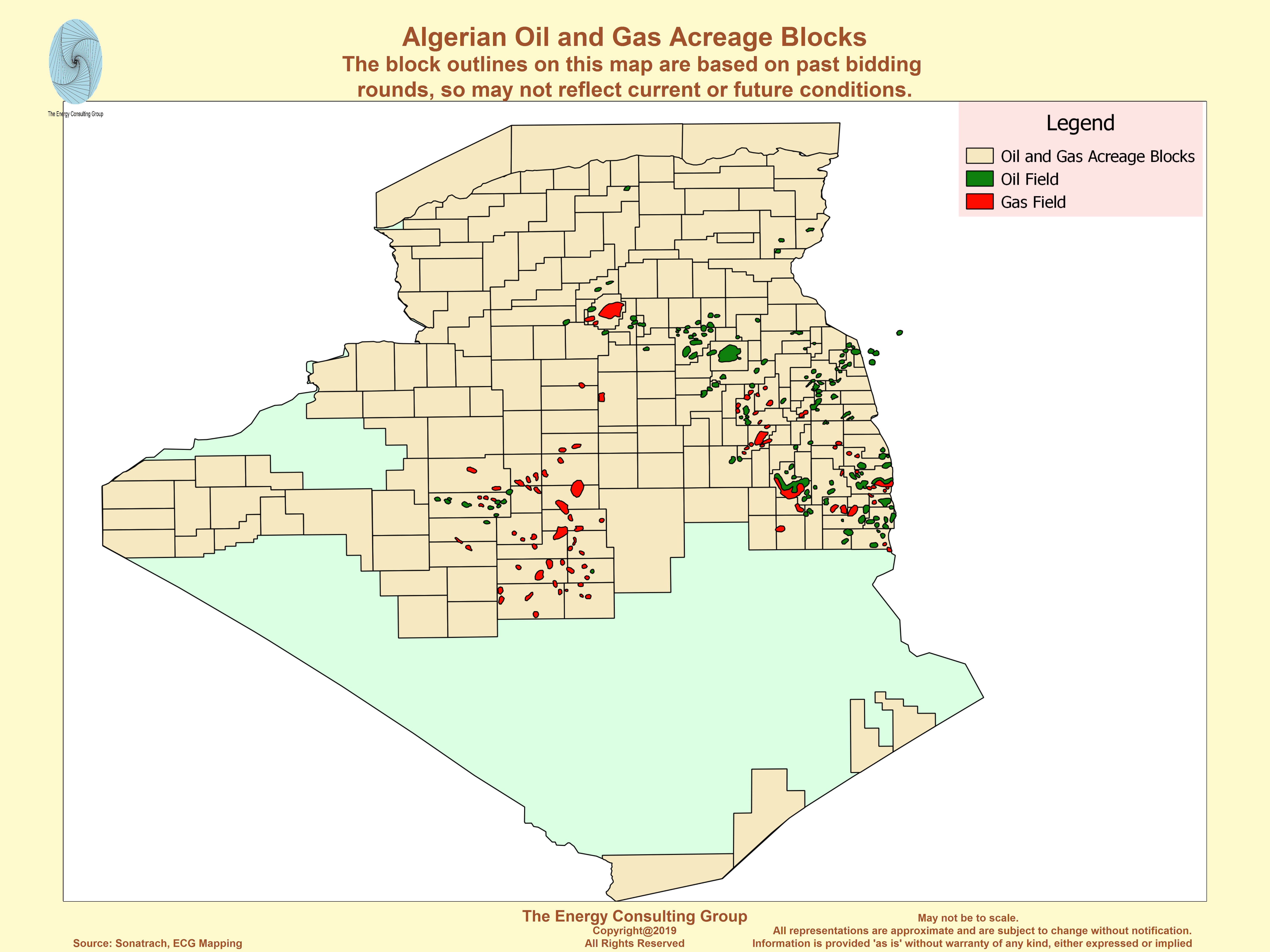
Crude oil and gross natural gas production have gradually declined in recent years, mainly because of repeated project delays resulting from slow government approval, difficulties attracting investment partners, infrastructure gaps, and technical problems. In the past three licensing rounds, there was limited interest from investors to undertake new oil and gas projects under the government's terms. As a result, the Algerian government enacted new contractual and fiscal provisions in 2013 in hopes of attracting more foreign investment to new projects, particularly toward unconventional assets (shale oil and gas, tight gas, heavy oil, and coal bed methane). In January 2014, the government launched its first licensing round since 2011. According to PFC Energy, 31 blocks, of which 17 hold shale resources, are being offered. All blocks are expected to be awarded in 2014.
Algeria is estimated to hold the third-largest amount of shale gas resources in the world, according to an U.S. Energy Information Administration (EIA) sponsored study. The EIA study estimates that Algeria contains 707 trillion cubic feet (Tcf) and 5.7 billion barrels of technically recoverable shale gas and oil resources, respectively. Some industry analysts are cautious about the prospects of Algeria becoming a notable shale producer. An analysis by MEES points out the obstacles Algeria will face, which include: the remote location of the shale acreage, the lack of infrastructure and accessibility to sites, water availability, the lack of roads and pipelines to move materials, and the need for more rigs because shale wells deplete quicker.
Any major disruption to Algeria's hydrocarbon production would not only be detrimental to the local economy but, depending on the scale of lost production, could affect world oil prices. Also, because Algeria is the second-largest natural gas supplier to Europe outside of the region, unplanned cuts to natural gas output could affect some European countries.
Algeria also relies on its own oil and natural gas production for domestic consumption, which is heavily subsidized. Natural gas and oil account for almost all of Algeria's total primary energy consumption. Domestic prices for oil products (diesel, gasoline, and liquefied petroleum gas) and natural gas are very low in Algeria by regional and global standards, according to the IMF. The IMF estimates that Algeria has the second-cheapest domestic price for natural gas in Africa, after Libya, as retail prices have not changed since 2005 and are now below operational costs. The IMF estimates that the cost of the implicit subsidies on oil products and natural gas (both in the intermediary and final-use stages) amounted to $22.2 billion in 2012, or 10.7% of GDP.
Natural gas accounts for 98% of power generation in Algeria,
according to the IMF. Like natural gas, electricity prices have also
been unchanged since 2005. However, the cost of gaining an electricity
connection to obtain access can be time-consuming and costly.
Nonetheless, more than 99% of Algeria's population has access to
electricity.
Source: U.S. Department of State
Oil and natural gas sector management
Algeria's national oil and natural gas company, Sonatrach, dominates the country's hydrocarbon sector, owning roughly 80% of all hydrocarbon production. By law, Sonatrach is given majority ownership of oil and natural gas projects in Algeria.
Algeria's oil and natural gas industries are governed by the Hydrocarbon Act of 2005. The initial legislation established terms that guided the involvement of international oil companies (IOCs) in upstream exploration and production, midstream transportation, and the downstream sector. The original 2005 legislation was more favorable to foreign involvement than its predecessor, which was passed in 1986. However, amendments to the bill were made in 2006, and some of the favorable terms were reversed. In the 2006 amendments, Algeria's national oil company, Entreprise Nationale Sonatrach (Sonatrach), was granted a minimum equity stake of 51% in any hydrocarbon project, and a windfall profits tax was introduced for IOCs.
Over the past few years, Algeria has experienced difficulties attracting foreign investors, particularly at licensing rounds. In the country's seventh licensing round in 2008, only 4 of the available 16 blocks were awarded, 3 of 8 in 2009, and 2 of 10 in 2011. Some analysts believe that the lack of fiscal incentives to attract foreign investors to new projects, coupled with past Sonatrach corruption allegations, were to blame. Algeria's precarious security environment has also been a concern for investors.
In 2013, Algeria revised parts of the hydrocarbon law in an attempt to attract foreign investors to new projects. Amid declining hydrocarbon production and stagnant reserves, the Algerian government has stated it needs foreign partners to increase oil and gas reserves and explore new territories, such as offshore in the Mediterranean Sea and onshore areas containing shale oil and gas resources. The 2013 amendments introduced a profit-based taxation, as opposed to revenue-based and lowered tax rates for unconventional resources, according to PFC Energy. The amendments also allow for a longer exploration phase for unconventional resources (11 years compared to 7 years for conventional resources) and a longer operating/production period of 30 and 40 years for unconventional liquid and gaseous hydrocarbons, respectively (compared to 25 and 30 years for conventional liquids and gas, respectively). The amendments, however, do not change Sonatrach's mandated role as a majority stakeholder in all upstream oil and natural gas projects.
Sonatrach owns roughly 80% of total hydrocarbon production in Algeria, while IOCs account for the remaining 20%, based on data from Rystad Energy. IOCs with notable stakes in oil and gas fields are: Cepsa (Spain), BP (United Kingdom), Eni (Italy), Repsol (Spain), Total (France), Statoil (Norway), and Anadarko (United States). Sonatrach's substantial assets in Algeria make it the largest oil and gas company not only in the country, but also in Africa. The company operates in several parts of the world, including: Africa (Mali, Niger, Libya, Egypt), Europe (Spain, Italy, Portugal, United Kingdom), Latin America (Peru), and the United States.
Security risks
Militant groups operating in North Africa and the Sahel have presented security risks to oil and natural gas installations in the region. In January 2013, a militant group stormed Algeria's In Amenas gas facility, resulting in several causalities and a temporary suspension of gas production at the facility.
Concerns over Algeria's security environment resurfaced on January 16, 2013 when a militant group attacked the In Amenas gas facility, resulting in several worker and militant causalities. The attack reportedly damaged two of the facility's three processing trains, of which each has the capacity to process 3 billion cubic meters per year (Bcm/y), or 106 billion cubic feet per year (Bcf/y). Gas output at In Amenas was first partially restarted at the end of February 2013 at one of the three trains. Currently, two of the three trains are operating, while the third train was still offline during the first half of 2014.
The In Amenas gas processing facility, located near the Libyan border, is jointly operated by Sonatrach, BP, and Statoil. After the incident occurred, BP and Statoil withdrew their staff from In Amenas and the In Salah gas facility (located 373 miles to the west of In Amenas), setting back plans to boost output at both projects. Some staff has since returned.
Natural gas output at In Amenas averaged 4.1 Bcm or 145 Bcf in 2013. Prior to the attack, In Amenas output averaged 7.8 Bcm/y (or 275 Bcf/y) of dry natural gas, accounting for almost 10% of Algeria's dry natural gas production and almost 16% of exports in 2012. Natural gas plant liquids (NGPL) are also produced at the In Amenas fields and averaged 43,400 barrels per day (bbl/d) in 2012, although nameplate capacity is around 60,000 bbl/d, according to MEES. Despite the absence of some personnel, production at In Salah remained relatively unchanged at 8.2 Bcm/y (290 Bcf/y) in 2013, compared with the previous year.
The In Amenas attack prompted companies to review their security at oil and gas installations in Algeria and other North African countries. The Algerian government has said it will increase security presence at all of its oil and gas facilities, particularly those in the remote south.
The In Amenas gas facility in Algeria
Source: BP
Oil sector
Reserves and exploration
Algeria holds the third-largest amount of proved crude oil reserves in Africa, all of which are located onshore because there has been limited offshore exploration. According to Sonatrach, about two-thirds of Algerian territory remains largely underexplored or unexplored.
According to the latest Oil & Gas Journal (OGJ) estimates, released in January 2014, Algeria held an estimated 12.2 billion barrels of proved crude oil reserves, an estimate that has been unchanged for many years. All of the country's proved oil reserves are held onshore because there has been limited offshore exploration. The majority of proved oil reserves are in the Hassi Messaoud province, which contains the country's oldest and largest oil field, Hassi Messaoud, located in the eastern part of the country, near the Libyan border. Hassi Messaoud is estimated to hold 3.9 billion barrels of proved and probable recoverable reserves, followed by the Hassi R'Mel field (3.7 billion barrels) and the Ourhoud field (1.9 billion barrels), according to the Arab Oil & Gas Journal.
According to Sonatrach, roughly two-thirds of Algerian territory remains underexplored or unexplored. Most of these areas are in the north and offshore. In the current licensing round, launched in January 2014, there are 6 northern blocks being offered, along with 7 central, 6 eastern, and 12 in western Algeria. There is also still potential to expand production in areas that have already been exploited, particularly in the Hassi Messaoud, Illizi, and Berkin basins. According to Sonatrach, the Hassi Messaoud-Dahar province contains about 71% of the country's combined proved, probable, and possible oil reserves, while the Illizi basin, the second largest area, contains about 15%. The Illizi and Berkine basins have been home to many discoveries since the 1990s and still hold significant potential.
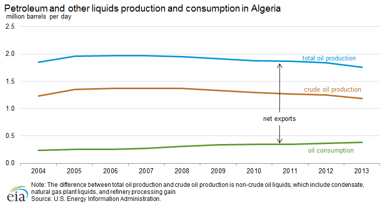
Production and development
The country produced almost 1.8 million bbl/d of total petroleum and other liquids in 2013, which includes crude oil, condensate, natural gas plant liquids, and refinery processing gain. The largest and oldest oil field, Hassi Messaoud, contributed more than 40% of total crude oil production, which averaged 1.2 million bbl/d in 2013.
Algeria produced an estimated average of 1.2 million bbl/d of crude oil in 2013, slightly lower than the previous year. Combined with almost 600,000 bbl/d of non-crude oil liquids, which are not included in its OPEC quota, Algeria's total oil production averaged almost 1.8 million bbl/d in 2013.
Algerian oil fields produce high-quality light crude oil with very low sulfur and mineral content. Sonatrach operates the largest oil field in Algeria, Hassi Messaoud, which produced roughly 500,000 bbl/d of crude oil in 2013, or more than 40% of Algeria's total crude output. Other large producing areas in Algeria include the Ourhoud and the Hassi Berkine complex. Algeria's largest oil fields are mature. Field expansions and enhanced oil recovery techniques have kept the country's oldest fields at a steady rate of production, but this trend is slowly starting to reverse. As a result, EIA projects that Algeria's crude oil output will gradually decline at least in the short and medium term.
Algeria does not have any major crude oil projects scheduled to come onstream. There are smaller new oil projects scheduled to come onstream (Bir Seba and Timimoun), along with additional output from existing fields (Gassi Touil-Rhoude Nouss and Hassi Messaoud), but the amount is expected to fall short of what is needed to offset natural decline rates at older fields. The Algerian government has been concerned with depletion rates at oil fields, and as a result, has temporary restricted production rates at some oil fields. In 2013, temporary restrictions were placed on the production rates of the mature Ourhoud field, the new El Merk field, and other fields.
The latest notable field to start production was El Merk, located south of Hassi Messaoud in the Sahara desert. Production started in early 2013, and output of crude oil, condensate, and liquefied petroleum gas (LPG) averaged roughly 165,000 bbl/d for the first quarter of 2014. Sonatrach and Anadarko manage the project, and other companies that have been involved in the field's development include Eni, ConocoPhillips, Talisman Energy, and Maersk Oil. El Merk is also expected to produce 220 Bcf/y of associated natural gas.
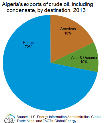
Crude oil exports
The vast majority (about 72%) of Algerian crude oil exports are sent to Europe. The United States was the single largest destination until 2013 when U.S. imports fell to 29,000 bbl/d, or by more than 75%, compared with 2012.
Algeria exports mostly light crude oil. The country's main crude grade is the Sahara blend, which is a blend of crudes produced at fields in the Hassi Messaoud region. In 2013, Algeria exported approximately 750,000 bbl/d of crude oil, including condensate, according to estimates from EIA, Global Trade Atlas (GTA), and FACTs Global Energy. Most of Algeria's crude oil exports are sent to Europe (72%), with the remainder sent to the Americas (18%) and Asia & Oceania (10%).
The United States was one of Algeria's single largest markets for crude oil for almost a decade until 2013. U.S. crude oil imports from Algeria have substantially declined in recent years. The United States imported 29,000 bbl/d of crude oil from Algeria in 2013, which is down from its peak of 443,000 bbl/d in 2007. The growth in U.S. light, sweet crude oil production from the Bakken and Eagle Ford shale plays has resulted in a sizable decline in U.S. imports of crude grades of similar quality, such as Algeria's crude oil.
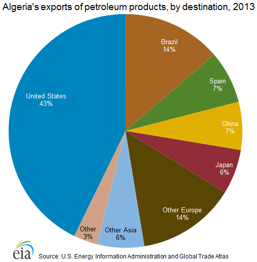
Petroleum products
Algeria has five oil refineries with a total nameplate capacity of 652,500 bbl/d. The vast majority of Algeria's domestic petroleum consumption, which averaged 380,000 bbl/d in 2013, derives from domestically refined products. Algeria's petroleum consumption has increased by an annual average of 5% over the past decade.
Algeria has five oil refineries with a total nameplate capacity of 652,500 bbl/d, according to the Arab Oil & Gas Journal. The country's largest refinery, Skikda, is located along Algeria's northern coastline and is the largest refinery in Africa. It has the capacity to process 352,700 bbl/d of crude oil and condensate, accounting for more than half of Algeria's total refinery capacity. Skikda processes the Saharan blend, which derives from the Hassi Messaoud oil fields. Algeria's two other coastal refineries, Algiers and Arzew, have the capacity to process 63,400 bbl/d and 58,500 bbl/d, respectively. The country's inland refineries, Hassi Messaoud and Adrar, are connected to local oil fields and supply oil products to nearby areas.
| Refinery | Capacity (thousand bbl/d) |
Type | Owner |
|---|---|---|---|
| Skikda | 352.7 | Crude Oil/Condensate | Sonatrach/Naftec |
| Hassi Messaoud | 163.5 | Crude Oil | Sonatrach/Naftec |
| Algiers (El Harrach) | 63.4 | Crude Oil | Sonatrach/Naftec |
| Arzew | 58.5 | Crude Oil | Sonatrach/Naftec |
| Adrar | 14.4 | Crude Oil | CNPC/Sonatrach |
| Total | 652.5 | ||
| Note: CNPC is the China National Petroleum
Company. Source: Arab Oil & Gas Journal |
|||
The vast majority of Algeria's domestic petroleum consumption, which averaged 380,000 bbl/d in 2013, derived from domestically refined products. Algeria's petroleum consumption has increased by an annual average of 5% over the past decade (2004 to 2013). Algeria typically produces a surplus of refined petroleum products, which is exported to global markets. According to GTA, based on data provided by Algeria's Customs Office, Algeria exported approximately 200,000 bbl/d of petroleum products in 2013, of which 43% was sent to the United States. Algeria also imports petroleum products, mainly from European countries and Russia. In 2013, Algeria imported approximately 75,000 bbl/d of petroleum products, according to GTA.
Oil pipelines and export terminals
Algeria uses multiple coastal terminals to export crude oil, refined products, LPG, and NGPL. These facilities are located at Arzew, Skikda, Algiers, Annaba, Oran, and Bejaia in Algeria and La Skhirra in Tunisia. Algeria's domestic pipeline network facilitates the transfer of oil from interior production fields to coastal infrastructure. The most important pipelines carry crude oil from the Hassi Messaoud field to refineries and export terminals. Algeria does not have any transcontinental export oil pipelines.
Natural gas
Reserves and exploration
Algeria holds the world's tenth-largest amount of proved natural gas reserves and the third-largest technically recoverable shale gas resources. In May 2014, Algeria's Council of Ministers gave formal approval to allow shale oil and gas development.
According to OGJ, as of January 2014, Algeria had 159 Tcf of proved natural gas reserves, the tenth-largest natural gas reserves in the world and the second largest in Africa, behind Nigeria. Algeria's largest natural gas field, Hassi R'Mel, was discovered in 1956. Located in the center of the country to the northwest of Hassi Messaoud, it holds proved reserves of about 85 Tcf, more than half of Algeria's total proved natural gas reserves. According to the Arab Oil & Gas Journal, Hassi R'Mel accounted for three-fifths of Algeria's gross natural gas production in 2012. The remainder of Algeria's natural gas reserves is located in associated and nonassociated fields in the southern and southeastern regions of the country.
Algeria also holds vast untapped shale gas resources. According to an EIA-sponsored study released in June 2013, Algeria contains 707 Tcf of technically recoverable shale gas resources, the third-largest amount in the world after China and Argentina. The Ghadames Basin, encompassing eastern Algeria, southern Tunisia, and western Libya, was identified as a major shale gas basin in the assessment. In May 2014, Algeria's Council of Ministers gave formal approval to allow shale oil and gas development. The Council of Ministers estimated that it would take 7 to 13 years to confirm Algeria's potential shale resources.
Production and development
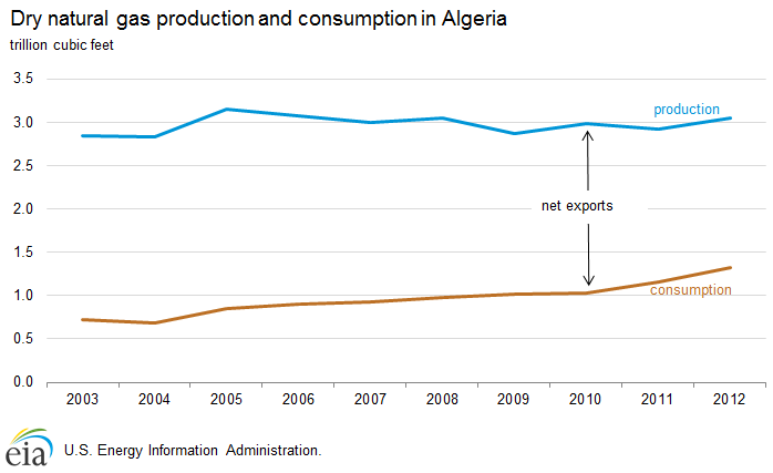
Algeria's gross natural gas production was 6.4 Tcf in 2012, a 4% decline from the previous year. Production has steadily declined over the past decade as output from the country's large, mature fields is depleting. There are several new projects planned to come online, but they have repeatedly been delayed.
Algeria's gross natural gas production was 6.4 Tcf in 2012, a 4% decline from the previous year. Algeria's gross production has been falling since its peak of 7.1 Tcf in 2008. The decline in 2012 mainly reflects fewer volumes of natural gas used to improve oil recovery by reinjecting it into wells.
In 2012, 56% (3.6 Tcf) of gross production was marketed, 42% (2.7 Tcf) was reinjected into wells to enhance oil recovery, and 2% (0.1 Tcf) was vented or flared. Despite the decrease in gross production, the marketed volume increased in 2012 by 4% over the previous year. Dry natural gas (a sub-category of marketed gas that occurs when associated liquid hydrocarbons are removed) was 3.05 Tcf in 2012, of which 1.3 Tcf was consumed locally and 1.7 Tcf was exported.
Algeria has been planning to bring onstream several new natural gas fields to compensate for the loss of production from mature fields, but many of these projects have been delayed by several years, mostly because of delayed government approval, difficulties attracting investment partners, infrastructure gaps, and technical problems.
| Project Name | Companies | Peak output (Bcf/y) 1 | Target start year |
|---|---|---|---|
| South West Gas Project: Phase 1 | |||
| Touat | GDF Suez/Sonatrach | 160 | 2017 |
| Reggane Nord | Repsol/Sonatrach/RWE/Edison | 100 | 2017 |
| Timimoun | Total/Sonatrach/Cepsa | 55 | 2017 |
| South West Gas Project: Phase 2 | |||
| Ahnet | Total/Sonatrach/Partex | 140 | 2018 |
| Hassi Ba Hamou | BG Group | 70-110 | -- |
| Hassi Mouina | Statoil/Sonatrach | -- | -- |
| Timimoun expansion | Total/Sonatrach/Cepsa | -- | -- |
| Isarene (Ain Tsila) | Petroceltic/Sonatrach | tbd | 2017 |
| Other gas projects | |||
| In Salah (expansion)2 | BP/Sonatrach | 200 | 2016 |
| Isarene (Ain Tsila) | Petroceltic/Sonatrach | 130 | 2017 |
| 1Billion cubic feet per year is
Bcf/y. 2Field expansion at In Salah is to ensure that the current level of output at In Salah is maintained. Source: Arab Oil & Gas Directory, Middle East Economic Survey, Repsol, Total, and Oil & Gas Journal |
|||
Algeria is in the process of developing its Southwest Gas Project, which includes the Reggane Nord, Timimoun, and Touat projects, all of which are expected to start production at the earliest in 2017, at least three years behind the initial schedule. The Repsol-led Reggane Nord project consists of developing six fields and is expected to reach a peak production rate of 100 Bcf/y. The Timimoun project, led by Total in partnership with Sonatrach and Cepsa, is expected to reach a peak production of 60 Bcf/y, and the Touat project, led by the France-based GDF Suez in association with Sonatrach, is projected to reach a peak production of 160 Bcf/y. The Southwest Gas Project entails the construction of gas-gathering facilities, a gas treatment plant, and a pipeline to the Hassi R'Mel gas hub, called the GR5 pipeline. The planned infrastructure will connect the remote Southwest gas fields to the Hassi R'Mel region and allow for the commercialization of other fields in the south as well. The development and commercialization of the Ahnet natural gas project in the south will also depend on the new infrastructure.
The Southwest Gas Project is very important for Algeria's ability to meet contracted exports and its expected growth in domestic demand. Gross natural gas production in the country will most likely continue to steadily decline in the short term, but it may recover in the medium term if planned projects come online and offset natural declines. Output from the Southwest Gas Project and other proposed projects (some of which are not included in the table) have the potential to increase Algeria's output by 1 Tcf/y or more after 2018. However, these projects are contingent on attracting investors and building new infrastructure or upgrading older infrastructure.
Midstream and downstream infrastructure
Algeria exports natural gas via pipelines and on tankers in the form of liquefied natural gas (LNG). It has three transcontinental export gas pipelines: two transport natural gas to Spain and one to Italy. Algeria's LNG plants are located in the coastal cities of Arzew and Skikda. Algeria was the first country in the world to export LNG in 1964.
Algeria's domestic natural gas pipeline system transports natural gas from the Hassi R'Mel fields and processing facilities, owned by Sonatrach, to export terminals and liquefaction plants along the Mediterranean Sea. There are three main domestic pipeline systems: Hassi R'Mel to Arzew, Hassi R'Mel to Skikda, and Alrar to Hassi R'Mel. The Hassi R'Mel to Arzew system is a collection of pipelines that move natural gas from Hassi R'Mel to the export terminal and the LNG plant at Arzew. The system also includes an LPG pipeline. The Hassi R'Mel to Skikda system transports natural gas from the Hassi R'Mel fields to the Skikda LNG plant, and the Alrar to Hassi R'Mel system transports natural gas produced in the Alrar and the southeastern region to the Hassi R'Mel processing facilities. Sonatrach plans to build the GR5 Southwest fields to the Hassi R'Mel pipeline to monetize natural gas reserves in fields discovered in southwestern Algeria. The expected completion date is 2017.
Transcontinental pipelinesone to Italy. The largest pipeline, Pipeline Enrico Mattei (GEM), came online in 1983 and runs 1,025 miles from Algeria to Italy via Tunisia. GEM's capacity is more than 1.3 Tcf/y and it is jointly owned by Sonatrach, the Tunisian government, and Eni. The Pedro Duran Farell (GPDF) pipeline started in 1996 and travels 325 miles to Spain via Morocco. GPDF's capacity is about 390 Bcf/y. The newest pipeline, MEDGAZ, came online in 2011 and is owned by Sonatrach, Cepsa, Endesa, Iberdrola, and GDF Suez. It stretches 125 miles onshore and offshore, from Algeria to Spain via the Mediterranean Sea.
Planned transcontinental pipelines
Algeria plans to develop two additional transcontinental export pipelines, although both have suffered delays, and it is highly uncertain whether both pipelines will be built. The GALSI pipeline is planned to transport natural gas to Italy via a pipeline with a subsea section. Initially, its capacity is expected to be 282 Bcf/y. The pipeline project has gone through feasibility studies, and there are concerns about logistics, costs, pricing formulas, and long-term contractual commitments. The Trans-Saharan Gas Pipeline (TSGP) is proposed to run slightly over 2,600 miles to deliver natural gas from Warri, Nigeria to Algeria (via Niger), which will then link to the MEDGAZ route to Spain, although this link may be changed in the future. However, security concerns about militant groups across remote areas in the Sahel, in addition to growth constraints to Nigerian natural gas production, have presented considerable downside risks to investors interested in financing the project.
Liquefied natural gas (LNG) plants
Algeria became the world's first LNG producer in 1964 when the Arzew LNG facility came online. In 2013, Algeria was the world's seventh-largest exporter of LNG, exporting about 5% of the world's total exports. Algeria has liquefaction units located along the Mediterranean Sea at Arzew and Skikda, with a total design capacity to process almost 3.2 Bcf per day of natural gas, according to PFC Energy. Sonatrach is building another LNG train at Arzew, with a planned capacity of 0.6 Bcf per day, to process natural gas output from the Gassi Touil project. Recent reports indicate that the plant may start exporting LNG in summer 2014.
| Pipeline name | Start year | Route | Length (miles) | Capacity (Bcf/y) |
|---|---|---|---|---|
| Pipeline Enrico Mattei (GEM) | 1983 | Algeria to Italy via Tunisia | 1,025 | 1,340 |
| Pedro Duran Farell pipeline (GPDF) | 1996 | Algeria to Spain via Morocco | 325 | 390 |
| MEDGAZ Pipeline | 2011 | Algeria to Spain via the Mediterranean Sea | 125 | 280 |
| Total export pipeline design capacity | 2,010 | |||
| Planned pipelines | ||||
| GALSI Pipeline | -- | Algeria to Italy | 534 | 282 |
| Trans-Saharan Gas Pipeline (TSGP) | -- | Nigeria to Algeria via Niger (link to MEDGAZ) | 2,602 | 706-1,059 |
| Billion cubic feet per year is Bcf/y. The GALSI Pipeline is initially planned to hold 282 Bcf/y of natural gas and may eventually double in capacity. The MEDGAZ link was identified as the favorable route in a past feasibility study, but this may change in the future. Source: Sonatrach (with EIA conversions) and Global Insight |
||||
Natural gas exports
Algeria exported more than 1.7 Tcf of natural gas in 2012, although preliminary 2013 data show that Algeria's natural gas exports fell by more than 10% to 1.5 Tcf in 2013. Approximately 90% of Algeria's natural gas exports were sent to Europe in 2012 and 2013, making it the region's second-largest natural gas supplier.
Algeria exported more than 1.7 Tcf of natural gas in 2012, of which approximately 1.2 Tcf was transported via pipelines and 0.5 Tcf by LNG tankers. Algeria is Europe's second-largest natural gas supplier outside of the region, after Russia. In 2012, more than 90% of Algeria's pipeline exports were sent to Italy, Spain, and other European countries, and the remainder was sent to Morocco and Tunisia as payment in lieu of transit fees. Also, more than 90% of Algeria's LNG exports were sent to Europe, primarily to France, Turkey, and Spain, and the remainder was sent to markets in Asia and Oceania.
Recent estimates from the 2014 BP Statistical Review show that Algeria's natural gas exports declined to 1.5 Tcf in 2013 (1.0 Tcf pipeline and 0.5 Tcf LNG), more than 10% lower than the previous year. The decline mainly reflects a substantial decrease of pipeline exports to Italy. Nonetheless, BP's data still show that Algeria was Europe's second-largest natural gas supplier in 2013.
Overall, Algeria's natural gas exports have gradually declined over the past decade, as gross production decreases and domestic consumption increases. Despite new export LNG infrastructure and increased capacity, Algeria's LNG exports have declined over the past few years. Algeria is facing pressure to boost natural gas output with new projects to meet growing domestic demand and to fulfill long-term contractual obligations to export natural gas to Europe.
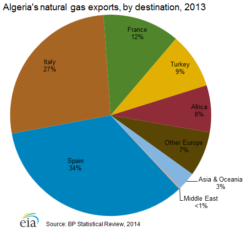
Electricity sector
Algeria's public utility, Sonelgaz, is pursuing a large-scale investment program to almost double electricity generation capacity in the next three to four years. The company has already made notable strides, as capacity increased by about one-third from 2011 to 2013. However, Sonelgaz faces some challenges as energy subsidies continue to affect its finances and as natural gas output has declined. Most of Algeria's planned capacity additions are from natural gas-fired plants.
Algeria's electricity generation capacity reached 15.2 gigawatts (GW) at the end of 2013, up from 12.9 GW at the end of 2012 and 11.4 GW at the end of 2011, according to Sonelgaz, the country's public utility in charge of electricity generation and distribution. Sonelgaz has brought additional capacity online to keep up with demand needs. In the past, Soneglaz has imposed rationing to balance electricity supply and demand. In 2012, the government enforced power cuts that provoked public protest in the summer months.
Net electricity consumption was 44 billion kilowatthours in Algeria in 2012, according to IHS Cera. Algeria's electricity consumption has increased by an annual average of roughly 10% from 2009 to 2012. The vast majority of generation capacity comes from gas-fired and combined-cycle plants, although the share of renewable energy in Algeria's generation mix is growing but still limited. According to the Electricity and Gas Regulation Commission (CREG), the country's electricity and gas market regulator, the national electricity system consists of an interconnected network that distributes power to northern and southern parts of the country. About 99% of Algeria's population is connected to the national grid.
Algeria's power demand peaks during the summer months, and demand is
expected to reach 12.5 GW in the summer of 2014. Algeria's peak demand
is expected to grow to 20 GW by 2017. As a result, Sonelgaz plans to add
more than 12 GW of generating capacity by 2017-18. Sonelgaz recently
awarded contracts for six combined-cycle gas turbines that are scheduled
to begin operating in 2015, according to MEES. Sonelgaz signed two
contracts for 23 solar photovoltaic projects, which are a part of a
400-megawatt (MW) solar capacity program that started in 2013, according
to MEES. Also, Sonelgaz plans to commission a 12-turbine, 10 MW wind
farm at Adrar this year, which is a pilot project for a wind capacity
program that plans to bring online 639 MW by 2023.
Sonelgaz is
planning to spend $7.6 billion from 2014 to 2017 to increase generation
capacity, not including costs for renewable projects, according to MEES.
The public utility plans to spend an additional $13.9 billion on the
transmission and distribution system. One of Sonelgaz's main challenges
is being able to finance the projects amid fixed electricity prices,
which has an impact on the company's finances. According to MEES, energy
subsidies in Algeria have resulted in deficits among Sonelgaz's
transmission and distribution subsidiaries of nearly $1.02 billion
annually. Another challenge is natural gas supply. Most of Algeria's
planned capacity additions are gas-fired units. However, Algeria's gross
natural gas production has been declining as new projects slated to
boost output have repeatedly been delayed.
Notes
- Data presented in the text are the most recent available as of February 5, 2014.
- Data are EIA estimates unless otherwise noted.
Sources
Afroil: Africa Oil and Gas Monitor (Newsbase)
Algeria Press Service
Anadarko
APEX Tanker Database (Lloyd's List Intelligence)
Arab Oil & Gas Directory
Bloomberg
Business Monitor International
BP Statistical Review of World Energy
China National Petroleum Corporation
CIA World Factbook
Electricity and Gas Regulation Commission
Energy Intelligence Group
FACTS Global Energy
Global Trade Atlas
IHS Cera
International Energy Agency
International Monetary Fund
Middle East Economic Survey (MEES)
Oil & Gas Journal
Organization of Petroleum Exporting Countries (OPEC) Secretariat
Oxford Institute for Energy Studies
PFC Energy
Platts
Repsol
Reuters
Rystad Energy
Sonatrach
Soneglaz
Total
U.S. Energy Information Administration
The Energy Consulting Group home page